September 9, 2016 - Mount Adams Wilderness - Gifford Pinchot National Forest
So before scheduling an MRI I would give my theory a real test. I decided – declared, in fact, to witnesses – that I would not backpack for the foreseeable future as that extra weight obviously added pressure on the legs. Secondly, I would restrict my hiking to established trails, foregoing (eschewing, if you will) off-trail gallivanting where footing is almost by definition going to be more precarious. By keeping to these two vows I would see if my knee could get stronger without further injury.
Three days later – Three days later! - I found myself not only off-trail but trying to descend a steep rocky slope at the base of Mount Adams, with every step I took starting some form of rock slide. It was as precarious a position as I'd been in years.
I had long wanted to hike up the southern slopes of Mount Adams. Photos of the peak from Trout Lake looked great, and icy peaks always look better from the south (in the northern hemisphere, that is), with the sun shining from behind the viewer. I'd read about a destination called the Lunch Counter, a base camp for climbers seeking to summit Adams, and it sounded like a good goal. So down to the Trout Lake ranger station, where I learned I would need to pay $15 for the hike, neither the Northwest Trail Pass nor the Senior Access accepted. Then came a long tough dirt road up to the trailhead, through the remains of a massive fire from a few years earlier. At one point I came upon a hole in the road I knew my Yaris could not handle and I backed up a couple of hundred feet down the narrow road, etched along a steep cliff, one side steeply up, the other abruptly down. A Suburu at the bottom was waiting for me to clear the road, and without a nod the driver proceeded up the road. I watched as he managed to squeeze between the hole and the cliff wall, and decided my car was no wider than his. So I followed his example and finally arrived at the trail head, more than a little flustered.
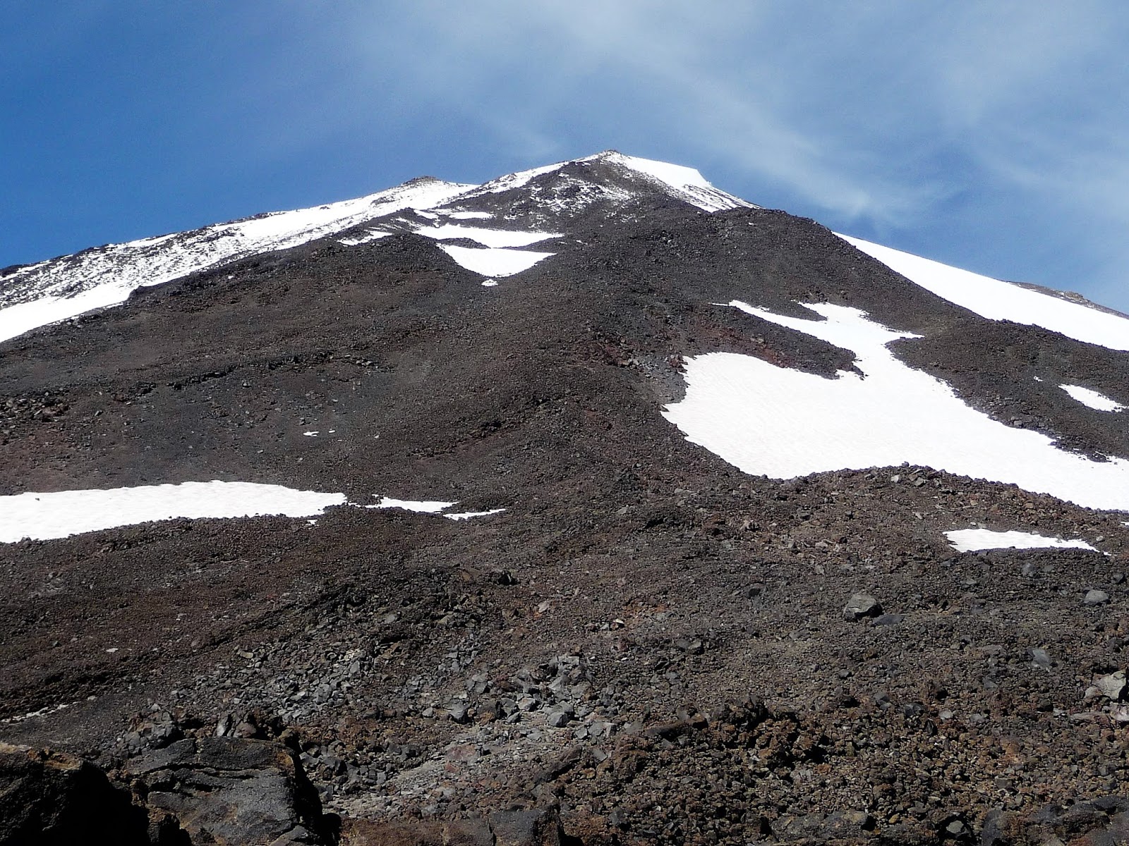
The trail started climbing through a continuation of the burn, always a bit pictorial. The fire had burned pretty much to timberline, and above it only a few scattered stands of whitebark pine stands provided relief from the expansive fields of gray volcanic rocks. In short, there was little shade the entire way up, and even though the temperature was rather pleasant, I was pretty hot. I imagine this hike would be brutal on a hot summer day. I also noticed that with each step my view of Mount Adams was decreasing. I hoped this would be a temporary development, but this hope would prove unfounded. The best views, it turned out, were on the road up.


 |
| Overview of Trail |

 |
| Last View of Mount Adams |
The trail climbed steeply up and around what my trail guide called a glacier, but I was unable to recognize any of the small patches of white as being an actual glacier. I suspect it is gone. The gray rocks then gave way to piles of purple volcanic boulders, almost razor sharp, not a good place to lose one's balance. A couple hikers were tentatively descending these boulders and asked me if this was the trail down. It appeared obvious to me and I assured them it was, but I didn't register that maybe it wasn't so clear on the way down. I had missed an important clue.
Finally I got to the large snowfield leading up to the Lunch Counter. I had known I would be crossing it but in the trauma of my drive to the trailhead I forgot to put on my UV glasses. I had to pull my hat as low as possible and squint a lot. It was a long way up, the most interesting snow feature of the day getting a bit larger with every step. At the top of the snowfield I spotted a large area of snow-free camps a bit to the west. No one was camped there but the boulders threw small patches of shade and I gratefully cowered in one as I nibbled at some lunch. The southern view of Mount Adams was not what I had hoped for, to put it mildly.
Over on the far side of the snowfield I saw groups of climbers hanging around. I thought maybe that was the Lunch Counter, and that it had better views of Adams than the one I had, but to get there I would have had to ascend more snowfield and I had had enough of that for one day. I was exhausted and knew I had a long way back. Ironically, if I had crossed over to that side I would have descended the proper snowfield, and quite likely avoiding the subsequent debacle.
Sliding down the snowfield was rather fun. I even essayed a posterior glissade, something I'd never tried before. I only did it once because I slid down so fast I could barely stop myself. Maybe I got a bit too engaged in the speed of my descent, as I missed another clue. I had spotted a young woman hiking down the other side of the snowfield but didn't really register that she had disappeared behind a rocky divide. I was complacent because I was following fresh footprints; others had gone down this way, recently. It had to be right. But when I got to the base of the snow I did not see the trail leading down. I didn't recognize where I had ended up, and only then realized I had gone down the wrong lobe of the snowfield.
I knew where I was in relation to where I wanted to be, so it was merely a question of how to get there. One choice was to double back up the snowfield and locate the proper lobe. That sounded awful. The other choice was to keep descending and gradually work my way to the east as I went along, which is what I did and how I ended up in my precarious position.
I happen to have a lot of experience descending steep rocky slopes and feel I'm rather accomplished at it. I tend to take it slowly and carefully and compared to a real climber I guess I'm not accomplished at all. Still, I always get to the bottom. This one was just tougher than I'd anticipated. As is usually the case, all the pebbles and small stones slid downslope almost on contact. The trick is to anticipate this and make sure you're not descending with them. The key is the big rocks: you have to use those as anchors, and usually it works. But this time the big rocks were some sort of slippery slate-like rock that wanted to slide as much as the pebbles. I had no anchors and I was in danger of launching a small rockslide that could take me down with it.
Progress was slow indeed as I worked my own switchbacks, down a bit with each lateral move. I had to calculate carefully, figuring out what was going to slide with each step. (There was no one else anywhere on the slope; I was not endangering anyone but myself.) A few big boulders held so I was able to rest a bit. By now I was dead tired but I was wary of resting too much because I was operating largely on the adrenaline of fear. If I rested too much I might lose that, my only real source of energy.
This all might sound terribly melodramatic, and I wondered even at the time whether I was making it harder than it really was. Sometimes the best thing to do is just plow more or less straight down, almost surfing the small rocks downslope, and I've done that before too. The problem was that if I were to do that my right knee would have had to lead the charge, digging in sideways with each step, and that was something I was simply afraid to do. I might have gotten down quicker but I also might have had to sit the rest of the year out with a knee operation. So down I picked, down I picked, and down I picked. A couple of those whitebark pine stands came in handy. They're not going anywhere, at least from my weight, though their branches are sharp enough to do some damage as well.
Eventually I was more or less at the bottom, in this god-forsaken graveyard of fallen rock. Now all I had to do was cross country to where I was supposed to be which I did but which also entailed more rocky descents. I regained the trail, my triumph deeply undercut by nervous exhaustion. Sunset on the burned out forest provided the only aesthetic relief.
Finally I got to the large snowfield leading up to the Lunch Counter. I had known I would be crossing it but in the trauma of my drive to the trailhead I forgot to put on my UV glasses. I had to pull my hat as low as possible and squint a lot. It was a long way up, the most interesting snow feature of the day getting a bit larger with every step. At the top of the snowfield I spotted a large area of snow-free camps a bit to the west. No one was camped there but the boulders threw small patches of shade and I gratefully cowered in one as I nibbled at some lunch. The southern view of Mount Adams was not what I had hoped for, to put it mildly.
 |
| Up the Snowfield |
 |
| View from the Lunch Counter (I think) |
Over on the far side of the snowfield I saw groups of climbers hanging around. I thought maybe that was the Lunch Counter, and that it had better views of Adams than the one I had, but to get there I would have had to ascend more snowfield and I had had enough of that for one day. I was exhausted and knew I had a long way back. Ironically, if I had crossed over to that side I would have descended the proper snowfield, and quite likely avoiding the subsequent debacle.
Sliding down the snowfield was rather fun. I even essayed a posterior glissade, something I'd never tried before. I only did it once because I slid down so fast I could barely stop myself. Maybe I got a bit too engaged in the speed of my descent, as I missed another clue. I had spotted a young woman hiking down the other side of the snowfield but didn't really register that she had disappeared behind a rocky divide. I was complacent because I was following fresh footprints; others had gone down this way, recently. It had to be right. But when I got to the base of the snow I did not see the trail leading down. I didn't recognize where I had ended up, and only then realized I had gone down the wrong lobe of the snowfield.
I knew where I was in relation to where I wanted to be, so it was merely a question of how to get there. One choice was to double back up the snowfield and locate the proper lobe. That sounded awful. The other choice was to keep descending and gradually work my way to the east as I went along, which is what I did and how I ended up in my precarious position.
I happen to have a lot of experience descending steep rocky slopes and feel I'm rather accomplished at it. I tend to take it slowly and carefully and compared to a real climber I guess I'm not accomplished at all. Still, I always get to the bottom. This one was just tougher than I'd anticipated. As is usually the case, all the pebbles and small stones slid downslope almost on contact. The trick is to anticipate this and make sure you're not descending with them. The key is the big rocks: you have to use those as anchors, and usually it works. But this time the big rocks were some sort of slippery slate-like rock that wanted to slide as much as the pebbles. I had no anchors and I was in danger of launching a small rockslide that could take me down with it.
Progress was slow indeed as I worked my own switchbacks, down a bit with each lateral move. I had to calculate carefully, figuring out what was going to slide with each step. (There was no one else anywhere on the slope; I was not endangering anyone but myself.) A few big boulders held so I was able to rest a bit. By now I was dead tired but I was wary of resting too much because I was operating largely on the adrenaline of fear. If I rested too much I might lose that, my only real source of energy.
This all might sound terribly melodramatic, and I wondered even at the time whether I was making it harder than it really was. Sometimes the best thing to do is just plow more or less straight down, almost surfing the small rocks downslope, and I've done that before too. The problem was that if I were to do that my right knee would have had to lead the charge, digging in sideways with each step, and that was something I was simply afraid to do. I might have gotten down quicker but I also might have had to sit the rest of the year out with a knee operation. So down I picked, down I picked, and down I picked. A couple of those whitebark pine stands came in handy. They're not going anywhere, at least from my weight, though their branches are sharp enough to do some damage as well.
Eventually I was more or less at the bottom, in this god-forsaken graveyard of fallen rock. Now all I had to do was cross country to where I was supposed to be which I did but which also entailed more rocky descents. I regained the trail, my triumph deeply undercut by nervous exhaustion. Sunset on the burned out forest provided the only aesthetic relief.
 |
| The Route of my Rock Descent |
 |
| Rocky Graveyard |
 |
| Burn at Sunset |
By the time I got back to the trailhead it was dusk. I was not about to drive down that road in the dark in my condition, so I would have to spend the night at the trailhead. Fortunately the trailhead had some very modest overnight camping sites and I was able to pitch my tent near a picnic table. It was a noisy night as many climbers were camping in the vicinity, so as to make an early start on the summit the next morning. A guy was sitting at the only table reading by red headlamp and I had to excuse myself and haul in my dinner paraphernalia. I had never seen a red headlamp and he told me it was what they used in the military. He was an Iraq veteran, on a break now from a post-military job in Afghanistan. He was a pretty interesting guy and we had a fairly pleasant conversation. I regretted being as absolutely exhausted as I was, as I was not able to engage him as much as I'd have liked to. A real writer would have had an interesting story here.

Trailhead Campground

Trailhead Campground


