Volcanic
rock here, a respite from the sedimentary stratification of the
Colorado Plateau. Bandelier National Monument is located on the
Pajarito Plateau, the very toe of the Jemez Mountains, the
southernmost extension of the Rockies. The Parajito Plateau was
created by two violent eruptions from Jemez Volcano one to two
million years ago, eruptions that covered a 400-square mile area with
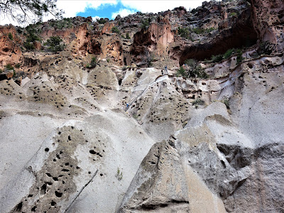
ash up to 1000 feet thick. Over time, this ash solidified into a tan
and pink rhyolite tuff that has eroded into cavity-pocked cliff walls
pervasive throughout the greater Bandelier region.
 |
| Bandelier Tuff |
Once
emptied of its content, Jemez Volcano collapsed into an enormous
bowl-like depression called a caldera. The remaining walls of the
caldera rim comprise a ring of mountains over
10,000
high, part of which constitutes the
northwest
border and
highest point of Bandelier National Monument. Streams
from
these high slopes have
cut
canyons 300-500 feet deep
through
the soft tuff of
Bandelier
on their way
to
the
Rio Grande some 12 miles away and five thousand feet lower in
elevation. Forested
mesa
tops above these canyons comprise the bulk of the monument’s
land
surface.
 |
| Frijoles Canyon (March 2017) |
Most
of Bandelier’s canyon streams are intermittent, with high flows
following
infrequent
storms and
lesser
flows
seeping into
the permeable
volcanic
soils the
rest of the time. The exception is Frijoles Creek, a spring-fed
stream that runs
year-round,
and it was
along this reliable water resource in the fourteenth and fifteenth
centuries that
people
from a
prehistoric
civilization now referred
to
as Ancestral Puebloan constructed a significant
urban-style
settlement, the ruins of which
provide
the centerpiece of Bandelier National Monument.
 |
| Frijoles Creek |
A Little Archeology
This
urbanized settlement came quite
late
in Ancestral Puebloan pre-history, four centuries after the renowned
architectural and cultural explosion began in the upper San Juan
Basin at
Chaco
Canyon. Though just
on
the other side of the Jemez Mountains, the Parajito Plateau remained
remote during this intense cultural development.
People
did not begin settling in the Bandelier area until around 1150, just
about the time that Chaco Canyon was rapidly losing population.
Whether these early settlers were part of the exodus from Chaco or
simply part of an expanding and dispersing
population,
they were a part of the historic migration pattern that would
eventually empty out the
population
centers of the San Juan Basin and generate new ones in and around the
northern Rio Grande valley.
The
early migrants to the Parajito Plateau settled
mostly
on the mesa tops above
the
canyons,
in
small clusters of single-story pueblos consisting of one to twenty
rooms. They
found
the
previously
uninhabited area rich in the native plants
and
animals
they
needed to supplement their agricultural sustenance. Times were good
and population grew steadily for over a century, with people
moving
around
the plateau in an effort
to
recapture the relatively pristine environment their very presence had
begun
to degrade.
As
population
continued to grow and
hunting
and gathering conditions
continued
to deteriorate, the people of the Parajito Plateau were forced to
increase their reliance on agriculture, this
just
as climate conditions began to shift and droughts became more
frequent. After peaking at an estimated
3,600
people around 1290, the population in the Bandelier area began a slow
decline.
Those
who
remained
at Bandelier began to what we might call urbanize, forming large
aggregations of multi-storied pueblos ranging from 40 to 600 rooms.
Several
such settlements sprung up across
the
plateau, but what would prove to be the densest and most long-lasting
was along the perennial stream in
Frijoles
Canyon. Large-scale construction began there in the mid-14th century,
centering around a
three-story, 400-room creek-side village known now as Tyuonyi. The
people also built a mile-long row
of
masonry houses up against the canyon
wall,
utilizing the cavities in the Bandelier tuff
to
create expanded interior dwellings, a unique combination of
cave
and excavation
archeologists
call “cavates”.
The village featured
fully
enclosed plazas and large subterranean kivas that reflected
a
more intense level of social organization than the Parajito Plateau
had yet witnessed, though far shy of what occurred in Chaco Canyon,
by this time almost entirely uninhabited..
The
community along
Frijoles
Creek made a good run of it. Between
1325
and 1440 the population increased from 200 to 550, peaking around 760
by 1500. By this time most of the people who still lived in
Bandelier
were living
in
Frijoles Canyon. But soon
this
population
began a decline that would prove total and permanent. By
1600 everyone was
gone, the uninhabited
homes
still filled
with personal belongings.
Frijoles
Canyon had little
to no human occupation from 1600 until the middle of the 1800s, when
Spanish land grant recipients ranched the area, using the masonry
from Tyuoniy for their own buildings and the wall cavates for work
space and sheep pens. The ranchers
were
gone by the end of the 19th
century
when residents from nearby pueblos
led
pioneer archeologists
to
the cliff house rubble and still-prominent cavates of
Frijoles
Canyon. This was a time when archeologists and artists
were
joining forces with the railroads in rallying
the
United States government to protect some portion of the many ancient
ruins being discovered throughout the Southwest. In 1916 President
Woodrow Wilson signed legislation creating
Bandelier
National Monument.
II
Juniper
Campground sits on a mesa some 600 feet above Frijoles Creek. A
hiking trail crosses the mesa top and then switchbacks steeply down
the cliff face, providing an overview of the circular remains of
Tyuonyi as well as some close looks at the pink pocked cliffs of
Bandelier tuff (3651). The cliff trail joins the Main Loop Trail as
it passes along several segments of cliff-house remains, their fronts
nearly all collapsed in rubble, though the park service has
reconstructed one for display. Holes high on the cliff walls (viga
holes) indicate where the fifteenth-century builders ran timber beams
for roof support, making evident the expanse of this condominium-like
architecture.

 |
| Bandelier Tuff |
 |
| Tyuonyi |

 |
| Windows and Viga Holes |
By
this point in my travels I had visited several Ancient Puebloan sites
and while I never tire of the settings and the story, I am no
connoisseur of masonry rubble. But the cavates dug into the
glittering white tuff cliffs at Bandelier are something special. The
park even provides ladders for visitors to access a couple. In quiet
times the setting can evoke times long gone. Even in busier time
poking around these rooms while admiring the shapely erosional
tuff formations
known
as tent rocks is a lot more fun than pondering
piles of collapsed rock.


 |
| Fun with Cavates |
Another
half-mile of trail leads to Alcove House and the highlight of the
loop, Not Alcove House itself, but getting to it, at least for the
sufficiently nimble, via four wooden ladders and a series of stone
steps climbing a total of 140 feet. Alcove House was two-stories high
and held 23 rooms but to my eyes it takes a back seat to the
surroundings. The
ascent ends in an alcove cave and a kiva,
reconstructed for public access but closed indefinitely pending roof
repairs. Visitors
cluster at the top or bottom of ladders waiting their turn, providing
opportunities
for socializing. It must be a mob scene in high season.


 |
| tent rock |
 |
| enclosed kiva |
Frijoles Creek
The
inhabitants of Frijoles Creek found the holey cliff walls suitable
for building, but
they remained
here as long as they did because of the year-round creek and its rich
environs. I was with them on that. The
cliff cavates were edifying and entertaining, but after several
months of desert and cactus the
leafy breezes of
Frijoles Creek seemed like a miracle. A
corridor of oak, box
elder, cottonwood, and ponderosa pine! I had been moving northward
and up altitude to
elude the
rising desert heat and though
it was already June this was my first encounter with spring. Higher
up the mountains were just barely
shedding winter, and
with mid-elevation national
park land a rarity I
was feeling very grateful for Bandelier National Monument.
It
would make a fine park even without the cliff dwellings but
obviously it
would never have been a park without them. Their existence and
protection
opens
up
a rare perennial creek to the public, a fine thing indeed.


I
continued
with the creek past
the Visitors Center and
down the gently sloping Falls Trail, a more solitary walk as 95% of
the park’s hikers stick to the Loop Trail. Here the canyon narrows
through a riparian area between the creek and a low tuff
wall, leaving less
room for habitation and no evidence of ruins. The sun was now high
enough to penetrate the foliage and I found temporary refuge beneath
a shady
little alcove along the creek, my first solitary dawdle along freely
running water since Big Bend in February. Entranced
by the
sun-dappled spring green I might have walked belly-on into a bear for
all I was watching where I was going. Instead
I came upon one of
the more unusual
trail signs I’d ever seen.


Upper
Falls is a mile and a half down the trail with a 400-foot descent,
most of that coming
near
the end where the
canyon cuts beneath
the Bandelier tuff into layers
of much older basalt, tuff, and sandstone buried
below. The falls itself drops 80 feet over what the trail guide says
is hardened lava from the throat of an ancient
volcano. The flow was
slight but refreshing to see in the midst of such
formidable
rock exposures.


 |
| Upper Frijoles Falls |
Another
mile to Lower Falls, a more modest 45 foot drop
resembling an outdoor
shower. Then a second sign,
a
bit more dire. While
I wasn’t exactly peeling my eyes it was hard to miss the gruesome
remains of a half dozen dead and rotting cows in the brush. Sorry, no
pictures. Here’s a flower.
 |
| Lower Frijoles Falls |


In
another mile the trail reached the banks of the Rio Grande, the river
running high and muddy with spring snowmelt. Compared to the lovely
creekside I’d just strolled through, this riparian landscape was a
mess. I took it for the remnants of recent fires but
eventually learned it was the doings of the Cochiti Dam a few miles
downstream. Built
in the 1970s ostensibly for flood control, it is
by all apparent evidence being used to hold back as much meltwater as
possible until downstream agriculture was ready for it.
 |
| Rio Grande |
 |
| Rio Grande Riparian Flood Remnants |
In
1985, wetter times almost a quarter of a century earlier,
heavy
runoff had backed up the reservoir enough to inundate 200-acres of
Bandelier riparian
area for a year and a half. This backwater
killed the plants and trees and when the water finally receded the
area was entirely reseeded by non-native plants brought downstream
from agricultural lands. This spot had held a
reputation as one of the
most beautiful parts of the park and was the monument’s most
popular backcountry destination. The Corps of Engineers reserved the
right to flood the land again whenever necessary, making restoration
efforts pointless. So the
park service abandoned the
trail, still passable twenty years later but no longer maintained.
This
is nothing compared to what
the
dam
did to the people of Cochiti Pueblo, descendants of some of the last
people to leave Frijoles Canyon. The Pueblo had
opposed
construction of the dam until it was forced upon them by Corps of
Engineers. Once built
it
flooded large percentages of their agricultural land; foisted a major
regional recreational destination into the middle of their small
community; forced them into an extensive soul and resource sucking
legal and political battle for any kind of redress; and worst of all
initiated a community divide between those people willing
to
wage this costly battle and
those
more ready to throw it in and pursue the economic benefits of
commercial development.
In
2001 the Corps of Engineers apologized to the tribe and the two
entities began working in a
more consensual manner. In 2014 the Corps took an unusual step and
returned to the tribe some of the land it had taken in construction
of the dam. Whether these steps
have resuscitated the
agricultural land or provided the tribe with any other compensation
are questions beyond my current research capacities.
III
In
the summer of 2011, just two years after my visit to Bandelier, the
monument was hit with a devastating one-two punch of fire and
flood.The fire began on June 26 when an aspen tree fell on a power
line eight miles outside the national monument. Conditions were
awful. The temperature was 89 degrees, seven degrees higher than
average and the first day in five not to have broken 90. Relative
humidity was 5% compared to the June average of 12%; again the four
days before had been even drier. Annual precipitation to date had
been roughly 25% of annual average. 40 MPH winds fanned flames up the
steep south facing slopes into a forest too thick and too littered
with downed trees following a century of fire suppression.
Firefighters
went after it almost immediately but the fire consumed 14,000 acres
within 14 hours and ended up burning 154,349 acres, the largest to
date in New Mexico’s history (a record it would hold for less than
a year). Known as the Las Conchas Fire, it burned more than 60% of
the park. The ruins and monument structures at the base of the canyon
escaped damage but Frijoles Canyon burned “with high severity”
for over 14 miles. Much of the ground was vitrified, a new term for
me. (It means to
convert something into glass or a glassy substance by heat and
fusion.) This is a landscape sculpted by fire,
but not by fire of this magnitude.
The
devastation so guaranteed flooding that even as the park service
personnel were rescuing artifacts and protecting (fire-sliming)
monument buildings, they were also laying out sand bags, removing
bridges, and taking other preparatory steps against the inevitable.
This came two months later, on August 21, when a major flash flood
swept through, destroying among other things the entire Falls Trail below Upper Falls - not simply the
trail, the entire cliff bench on which the trail was placed. The
Lower Falls Falls Trail was closed indefinitely and likely for good.
Too bad. I’d love to get back there and see what it looks like now
that I’d know what I was looking at.
The
2011 flood was just the beginning. Flooding recurred each subsequent
year and in September 2013 the largest flood in recorded park history
came sweeping through. By the time I returned in March 2017 the trail
system, reportedly the best in the Jemez Mountains, was largely
speculative. Nearly all park trails were damaged and some were
destroyed. Recurrent flooding outpaced ongoing repair efforts. The
park continued to allow hiking but its website issued a packet of
warnings. Remaining trails would be difficult to follow and familiar
landmarks were likely gone. Shade would be harder to come by and the
trees that remained were more likely to come crashing down. Trail
junctions in canyon bottoms had been obliterated by floods making the
location of trail routes exiting the canyons difficult to find.
Excess growth of vegetation following summer rains would also obscure
trail routes.
All
of this was on the park website but of course I did not consult the
park website. I did peruse the park’s hiking map, color-coded
to signify the degree of disrepair for
the
respective trails. I hoped to hike the Frijoles Creek trail - a
13-mile loop going five miles up the canyon and returning atop the
Canyon Rim. It
was
coded red, signifying “most damaged”. The ranger at the Visitor
Center, however, told me that downed trees, not route finding, had
earned the red
designation.
He didn’t mention that the park website described the trail into
Frijoles Canyon as “passable but challenging in places due to
erosion, rockfalls, fallen trees, log jams, flood debris, dense
vegetation and numerous stream crossings.” I guess he figured I’d
checked the website.
So
I set off up the creek, figuring I would just
go
as far as I could manage and then turn back. In fact the downed trees
weren't much of a problem. They were dry and sharp and unreliable for
foot or hand-holds but not really very challenging, certainly not
compared with Deception Creek in the Alpine Lakes Wilderness, say,
before that trail crew comes through.
The
difficulty came with the creek crossings. Countless creek crossings!
The water was never dangerous, just a soaking to the shins, and some
better shod than I might have just plowed through. I opted for the
dry approach, and for a while enjoyed solving the problem each
crossing posed. I can always use the practice. But they just kept
coming and eventually I lost my enthusiasm. Nearly every one required
some kind of leap and this began to sap more spring from my legs than
they could spare. I started tripping over things and I fell down
twice, no harm incurred but convincing me to sit for a while to rest.


 |
| Frijoles Creek |
The
creek cut through some nice pink cliffs but with all the jumping I
wasn't paying that much attention to the pink cliffs. At one point I
turned a corner and walked into a wall of black flies and had to
jump over the carcass they were feeding on. I didn't verify what it
was – deer probably – as it had enough meat on it to maybe hold
some proprietary interest for a cougar. I scurried along.
By
this point I realized I had committed to completing the 13-mile loop
trail, a longer hike preferable to jumping across the creek
a million more times on the way back. The risk was in how bad the
rest of the canyon might be. I felt I had already covered the five
miles I needed to get to the high crossing that would bring me to the
return leg of the loop. I scanned the high slope above but saw no
trail. It dawned on me that five miles was the length of a trail that
no longer existed. It did not account for the constant back and forth
across the creek bottom.
Two
guys had set out on the trail ahead of me – looked like father and
teenage son – and they hadn't looked exceptionally hardy. I
figured that if things had gotten too rough they'd have come back my
way and given me the low-down. I realized they may have passed my by
when I sat to rest, or possibly vice-versa. But finally back they
came, reporting that the terrain up creek only got worse, and that
according to their phone they had already traversed six-miles without
coming to any high crossing. But the father also mentioned that he
had spotted some flags somewhat upslope so maybe I
could find a better way. And sure enough I soon found a trail of
flags, different colors signifying who-knows-what, leading me up to a
bench trail, level and easy, the world a far better place to be.
Still,
the trail just kept going and I did fear I had missed the rim trail
cutoff, or it had been destroyed, and that I was now going the wrong
way, bringing to mind my favorite Yogi-ism – we may be lost but
we're making great time. Quite abruptly a side trail cut back up the
slope. No trail sign but no doubt either and up the steep burned out
slope I went. God was nice enough to provide some big clouds for
shade during my ascent and then withdrew them when I got to the top,
allowing me to get some decent pictures of the fire-ravaged scene. A
fine God-like performance.


 |
| Frijoles Canyon |
Then
it was just a long slog across a mildly windswept mesa of grass and a
scattering of burnt trees, some still standing. I surmised that this
mesa had been thoroughly burned by an earlier fire that left little for the 2011 fire to burn. It was pleasant if shadeless walking, too
far from the rim for views. My legs were sore but my feet felt
alright thanks to a trail surface of volcanic sand. I came upon two
more people, the only ones I'd seen other than the father-son team,
resting their bones as well. We compared notes on the downed trees
and creek crossings and it took a bit of conversation and a couple of
incongruities for us to realize we'd had the same experiences on two
different trails. Finally the trail got close enough to the rim for
some impressive views, and then a quick descent to the canyon floor
where I had a lovely dinner in the shade of the ponderosa pine.
 |
| Alamo Mesa |
 |
| Frijoles Canyon Wall |
 | ||
Some Less Obvious Sources
The
Bandelier Archeological Survey, ed Robert P. Powers and Janet D.
Orcutt (1999 Intermountain Cultural Resources Management/Professional
Paper No. 57)
Biotic
and Abiotic Factors Contributing to New Mexico’s Largest Wildfire:
The Las Conchas Fire, Laura L. Trader, Fire Ecology Program Manager,
Bandelier National Monument, National Park Service( Spring
2012/RxEffects: National Park Service U.S. Department of the Interior
Fire Ecology Program)
Pinel Sandra Lee, Stopping
the Flood of Damages from Cochiti Dam (Cultural
Survival Quarterly Magazine June
1988)
Indian Country Today, Cochiti
dam changes pueblo way of life Aug
18, 2009
Regis
Pecos, The History of Cochiti Lake from the Pueblo Perspective, (47Nat.
Resources J.639 (2007))
Robert Julyan The
Mountains of New Mexico P.83 (UNM Press 2006)
Patricia Barey, Bandelier
National Monument (Western National Parks
Association
1990) |