Dinosaur National Monument - Utah and Colorado - May 2017
1)
The
primary attraction of Dinosaur National Monument, the
reason for the park's
initial protection
and the reason
most people visit,
is the Dinosaur Quarry Exhibit Hall. Here the National Park Service
houses what remains of
“the single most
important Jurassic dinosaur paleontological site to be found
anywhere.” In August 1909, a young paleontologist by the name of
Earl Douglass made a significant discovery on this spot: eight tail
bones of a dinosaur now known as Apatosaurus, set in the exact
position they were in when the animal was alive. Further digging
uncovered nearly the entire skeleton, the most complete Apatosaurus
ever discovered. And this was just the beginning. Over the next
several years, intense excavation
at the site unearthed
bones from 400 individual
dinosaurs
representing
14 different species.
While
the excavation didn't
produce significant new discoveries, what
it produced, other than
abundance,
was quality.
These were some of the
most complete and best preserved specimens of their type, perfect
for both study and display. Some
350 tons of bones were
shipped off to museums,
mostly to Carnegie Museum of
Pittsburgh which sponsored the excavation, including
20 skeletons complete enough
to be mounted.
These
dinosaurs lived about 150 million years ago, well
before the time when
dinosaurs went extinct some
65 million years ago. They
represent just
a day in the life
near
the midway
point of the 160
million years
the Dinosaurs
lived on earth.
Paleontologists have
concluded that
these particular animals
had lived
along a large river and that
a drought had forced them to gather closely
around a dwindling water source. Many
died there, and seasonal
floods swept
both living and dead
down to a tight bend in the river, where
they were hung
up, quickly
buried in
mud, gradually pushed
deep into
the ground where they remained
intact until mountain
building lifted them back up
above the surface. Finally
erosion
slowly removed
the overlying rock layers
so that there they were, in
the early 20th
century, lying there waiting
for the right
aspiring dinosaur bone
hunter to come along.
I find the whole thing very
mind-boggling.
In
1915, at the request
of the Carnegie Museum,
President Woodrow Wilson
declared
80 acres around the
excavation site a national
monument in
order to protect the
remaining fossils
from looters or homesteaders. By
1922, Carnegie decided
it had all the dinosaur
bones it needed, and
while Douglass kept at it for a couple more years on behalf of the
Smithsonian Institute, work
at the
Dinosaur Quarry
soon went
into hiatus for more
than twenty-five years.
Excavation
kicked back into gear in the 1950s, and
in 1958 the Park
Service erected
a building around the site
and allowed people to come in and watch
as paleontologists went
about their work. But
by the early 1990s Quarry
production had
reached diminishing returns and
excavation shifted elsewhere in the monument, where
paleontologists could find
fossils of smaller
animals that had lived
alongside the dinosaurs. As for the Quarry, the park service
left more than 1,500
fossilized bones from
100 dinosaurs on display for
public perusal, the bones
half-excavated, lying
essentially as
they were buried some 150
million years ago.
I've
never had any interest in
dinosaurs, never even saw
Jurassic Park, but
I was certainly ready
to go take a look at a world
class dinosaur exposure right
under my nose. It
was a strange sight. A wall
of rock 150-feet
long
and two stories high,
tilted
up at a sharp angle, a
geological happenstance that makes
for great viewing. Bones of
all sizes and shapes were
strewn about, open-face
as it were.
One guidebook
compared it to “the leavings of an enormous turkey dinner”, but
after examining it for a
while I felt like
I was looking at exactly what I
was looking at, an enormous
mass grave. I
get it. People
with greater interest than I can use their binoculars and identify
the various bones. But it
left me feeling bereft.


On
the other hand, the small museum
accomplished
what a museum is
supposed to, it piqued my
interest. In about 45
minutes I learned more than
I'd ever known about
dinosaurs, though
probably not so much as your average seven-year old already knows.
In fact I went back a second
time to review the museum displays and did not even look at the bones
in the wall. The great
majority of the buried
dinosaurs were sauropods,
which means,
I learned, long-necked dinosaur.
An
adult sauropod weighed 25 tons, the
largest animals ever to walk on earth. They
were herbivores, and very
numerous. The
single-most represented dinosaur at
Dinosaur Quarry is a
sauropod named Camarasaurus,
one of which remains
to this day the
most complete sauropod dinosaur skeleton ever found anywhere.
The
Quarry also yielded
enormous numbers of
Stegosaurus bones - a
familiar looking dinosaur
with rows of plates on
its back and spikes along
its tail - so many that
Douglas complained they were
in his way when he worked to
unearth his Apatosaurus. In
1977 the Quarry yielded the
most complete juvenile Stegosaurus ever found.
Another
herbivore, Stegosaurus is an
Ornithischian, which I
guessed might refer to its armor but in fact means “bird-like
hips”. Not all Ornithischians are armored, or
herbivores.
 |
| Stegosaurus model outside Visitors Center |
 |
| I knew you wanted to see this face |
The
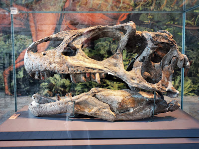
Quarry also yielded meat-eating dinosaurs, called Theropods, though
in lesser numbers as is typically the case with predators. The Quarry
yielded the bones of the
Allosaurus, a
ferocious predator that walked on hind
legs, and
the
museum displayed a real Allosaurus skull in a glass case. Bones
in glass cases didn't bother me. Just the ones strewn about the wall.
 |
| Allosaurus skull |
Rarely
afraid to show my
ignorance, I asked the ranger on duty some questions. What about the
Brontosaurus, one of the most
well known dinosaurs
as far as I knew
but one that a seven-year
old friend of mine summarily
dismissed
when I brought it up in
conversation? Was
that just something
they
made up for the Flintstones? Not
at all, she
answered. In fact the
question turned out to be
relevant to
the Dinosaur Quarry. When
Earl Douglass
found the Apatosaurus
skeleton that launched the
Dinosaur Quarry he called
it a Brontosaurus. But
he
was just a
little out of date. Some
thirty years earlier, the
two leading
paleontologists
of the day
had made
similar sauropod discoveries. Edward
Cope
named his discovery the
Apatosaurus and
O.C. Marsh
named his the Brontosaurus.
This was just one of the
issues Cope and Marsh faced
off on as they waged
a poisonous public feud
about nearly everything for
the entirety of their careers.
In 1902 some scientific authority concluded the two
animals were
the same species, and since
Cope had named his first, Apatosaurus
became
the scientifically accepted name. Brontosaurus
was relegated
to mere popular nomenclature. Recently though, some
paleontologists have begun to press the case that Brontosaurus was a
legitimate separate species and so the
question is
back up for grabs, hopefully
in a more civil manner.
Emboldened,
I pressed on. How about
Tyrannosaurus Rex? Was
that for real? Yes indeed.
But it did not evolve for
several tens of
millions of years after the demise of the Dinosaur Quarry dinosaurs.
In fact the Tyrannosaurus
was around about the time the dinosaurs went extinct. I
realize I could be the last person in the world to know this. But I
know it now.
2)
Ironically,
Dinosaur Quarry is just a small part of Dinosaur National Monument.
The Quarry is near the Visitors Center at the park's entrance and why
most people drive into the park, but it takes up a very small part of
the 210,000 acres that comprise the monument, most of which contains
no dinosaur bones. The remaining acreage, added
by FDR in 1938, consists of two extraordinary river canyons,
58.5 river miles of the Green River and 47 miles of the Yampa River,
as well as their surrounding mesas. This expanse is largely roadless,
accessed mostly by boat, with very few points of entry. So other than
those viewing Dinosaur Quarry, most of the park visitors are the
15,000 or so who run the river each year.
Now
that might seem to leave me, coming neither for dinosaurs nor river
running, in the (not terribly unfamiliar) position of odd-man out.
But no, the monument also protects what it calls the canyon viewsheds, a word I'd never heard before, but precisely what I was
there for: the fantastic landscapes that I trusted would encompass
these river canyons.
My
hopes were bolstered as I approached the park, driving through
private ranch land, when my eyes were commanded by Split Mountain, a
thick, looming nearly-white sandstone ridge deeply eroded by high
dangling canyons. I became so engaged with thoughts of scrambling up
this fine looking rock that I almost didn't register that the ranches
had given way to another wonder, the slow lulling sweep of the Green
River, ushering me into the park through sagebrush fields just off to
my right. This stretch of calm river is an anomaly within Dinosaur.
The Green had just finished slashing through over fifty miles of
monument canyons - Lodore, Whirlpool, and Split Mountain the most
significant.
 |
| Split Mountain looming above Green River |
.
After
entering the monument and driving through a gauntlet of jagged
hogbacks, I followed signs for the campground down a steep road to my
left, directly toward Split Mountain. My eyes were now peeled for the
campground (always an anxious time: is it nice, is it filled, will I
get a good site, will I have quiet neighbors?) but all I could see
was what looked like a large working ranch. Was Dinosaur outdoing
Capitol Reef with the rural economy theme? No, the ranch – a
private inholding that long predated the national monument – was on
the other side of ... the Green River, which I had just turned
directly away from. It seems the river, after tumbling out of Split
Mountain Canyon, had flowed passed the campground and made a
180-degree loop to begin its languid stretch past the monument's
entrance. This was just the first of much puzzling geography
presented by Dinosaur, which crosses two states (Utah and Colorado),
features two major rivers, contains large private property inholdings
as well as great swaths of Bureau of Land Management land. It would
take me a while to get my head around it.
 |
| Overview of campground, Green River, and Chew Ranch |
 |
| Green River making its U-turn |
The
campground itself was fine, mostly grass and stressed cottonwoods
flanking a rather ratty riparian reach, an abandoned floodplain in a
dry, cold region (ten inches of precipitation a year with winter
temperatures sometimes below zero). Ratty aesthetically not literally
but squirrely it was: brazen ground squirrels who come after your
food and will not be dissuaded. The campground host told me one had
grabbed a piece of hot dog from a young child and I believe it, as
once before one had climbed up my back in an effort to snatch my
sandwich from over my shoulder. Here I took to eating my granola far
from my picnic table when it appeared one particularly determined
squirrel was preparing to leap into my bowl.
Squadrons
of Canadian Geese loudly patrolled the river corridor, while in the
ranch across the river a bevy of cows provided quality bellowing. A
few polite horses grazed picturesquely, particularly near sunset.
Ranch dogs barked through the night. Since they were quiet during the
day I supposed they were doing night patrol, but I heard no coyotes
so I wondered what exactly they were barking over. The host assured
me there were all sorts of critters out there. The river itself was
flat and quiet. I could hear but a slight murmur and then only at the
quietest time of night. The air, though, was alive with bird song,
some of it very remarkable and I wished I could reproduce it. Several
birders wandered about and one informed me that the one I found most
visually striking, particularly in flight, was known as the Bullock
Oriole.
Looming
above the campground, so close and so tempting, were the wonderful
canyoned domes of Split Mountain. But alas they proved out of reach.
Not only was the mountain on the other side of the river (not that I
would swim across), it was separated from the river by the private
ranch. The ranger advised me that hiking to that portion of the
mountain was possible but would entail a long, off-trail trek. I
would have to settle for the view, at least on this visit.
Split
Mountain is actually split, cut in two
by the
Green River. The
first scientific explorer
of the Green,
the geologist
John Wesley Powell, concluded what seemed obvious: the river was
there before the mountains
and was able to cut downward
as fast as the mountains
could rise up around
it.(2) This is called an
antecedent river and is a
common enough
phenomenon. It is the way the
Columbia River cut the Columbia Gorge through the Cascade Range.
But
it wasn't what happened here. Subsequent geologists found evidence
that the mountain was much older than the river, suggesting that the
river had cut straight into an existing mountain rather than flow
around it. Since that is basically impossible another explanation was
called for and it proved to be this: the mountain was there before
the river but the mountain was under ground. The Uinta Mountains, of
which Split Mountain is a mere foothill, were once far greater
mountains than they are now (and they are still pretty great
mountains). Over the millennia they eroded down toward their current
status, shedding enough debris to bury the likes of Split Mountain.
Green River eventually came along, wore through the easily-eroded
erosive rubble, and cut its river bed down until it essentially dug
up Split Mountain. By this time the river was too deeply entrenched
to do anything but keep cutting down, creating Split Mountain Canyon
more or less through the middle of Split Mountain. (For those seeking
class credit, the term for this type of river is called superimposed.)
 |
| Split Mountain/Green River |
 |
| Split Mountain and Split Mountain Canyon |
A
ten-mile road extends past the campground, over the river and through
the ranch to some of the monument's more accessible features, the
activities the rangers recommend to those looking to spend an hour or
two at the park after visiting the Dinosaur Quarry. I had at least
two weeks but the weather was not yet conducive to the longer
excursions I planned so I quite happily did what there was to do near
at hand.
A
modest climb up a rocky cliff yielded some fine petroglyphs etched
into the rock, which archaeologists identify as the work (play?) of
the Fremont culture, semi-nomadic people who lived on the Colorado
Plateau from A.D. 200 to 1300. The petroglyphs themselves cannot be
dated, but may be up to one thousand years old. I had spent most of
the spring on the Colorado Plateau and had seen a fair number of
Fremont pictographs (one could spend a whole lifetime and see
millions more), but a few of these were unique. A large, well-worked
lizard instantly became my favorite petroglyph to date. A seemingly
Monty Python-influenced illustration was the most outlandish I'd ever
seen. And a striking female head was clearly the inspiration for the
signature self-portrait of the mother of the (then) seven-year old
dinosaur critic.
A couple of short trails wound through the geologic rubble lying beneath Split Mountain and provided some fine views.
 |
| I just barely avoided jumping on to this rock before I noticed the snake. Don't know if it is poisonous. |
Another
short trail wandered through the 19th-century homestead of
a pioneer woman named Josie Basset Morris, who built her own cabin in
1913 and lived there for over 50 years. A bit of a renegade for her
day, she was married five times, divorced four, her last husband
dying somewhat mysteriously. As a youth she had a (documented)
acquaintance with Robert Parker, the outlaw known as the Sundance
Kid. She later claimed to have renewed that acquaintance some ten
years after he was reported gunned down in Bolivia. That portion of
her story remains distinctly undocumented.
Her
homestead was very successful thanks in part to its location at a
canyon at the base of Split Mountain, which is comprised almost
entirely of a rock formation called Weber Sandstone. Sandstones are famously porous, absorbing
precipitation and generating seeps and springs at their base. This
canyon is particularly productive and she used the abundant seepage
to cultivate a rich fruit orchard that even today is the most plush
canyon mouth I've seen.
 |
| Josie's Cabin |
 |
| To Josie's Orchard |
3)
All
of this was fun but
I was just
biding my time, waiting for some
decent weather before
heading
out to what for me was most alluring attraction
of Dinosaur National
Monument: Harper's Corner,
overlooking
the confluence of the Green
and the Yampa Rivers.
I have a thing for stream
confluences and this is a big one.
The Green, rising
in the Wind River Range of Wyoming, is
the largest tributary to the Colorado River, nearly equal in flow to
the Colorado at their confluence. The Yampa is the
largest unregulated tributary remaining in the Colorado River system.
It
rises
on the western slopes of the Colorado
Rockies and
runs
some 200
miles before digging into Dinosaur National Monument.
On
top of this confluential
significance,
Harper's Corner promised
what Ralph Lee Hopkins,
my primary
guide to exciting geology on the Colorado Plateau (3), calls
a spectacular birds-eye
view of
an extraordinary
geological phenomenon.
Supporting this
opinion, the Dinosaur park
brochure features
a small photo
of the view, in brilliant
light, a black
bear implausibly
superimposed, that had
been taunting me since I'd
arrived.
So
on the morning with the
first promising
forecast - mostly
sunny with a chance of late afternoon thunderstorms, perfect,
I was off as
early as I could manage (8:30)
for the 60
mile drive. The
Harper's Corner Road is the one paved road that does penetrate deep
into the monument,
traversing private ranches
and BLM land along the way,
criss-crossing state lines
and
ending up in Colorado. I got
there way too late for good
morning light, but
I was too excited to care,
too excited to even change to hiking shoes, and I
set off
along the one mile trail for
what good
light remained. I knew this
was just an introductory
walk. I planned on staying around
Harper's Corner all
day, hopefully until sunset.
The
short trail
runs through a by-now
very familiar forest of
juniper and pinyon pine. A
few window views opened
out
to tempting landscapes
but I didn't linger, heading
straight for the climactic
overlook. Only
near its
end does
the trail emerge from the brush, jutting
out onto
bare exposed rock,
cliffs dropping almost
straight down 2500 feet to
the river. Those who wish
can stay behind a safety
guard rail.
The
scene was truly epic and hard
for me to
describe, but here goes. The
overview is perched
at 7,580 feet, 2,500
feet above the canyons below
From
this point the two
rivers are visible only as
glimpses as they flow
toward their
confluence;
they
are largely
implied by the canyons they've cut into the mountains.
The Yampa meanders
in more or less from the
east, through a maze of deep
Weber Sandstone
canyons,
meandering that is through a
thousand feet
of hard rock, which is
preposterous. If a river is
going to cut a canyon it cuts
it straight
down, it
does not meander.
As with the
Green River in Split
Mountain Canyon, the Yampa is
superimposed. It did once
meander through erosive
debris before entrenching
itself into the sandstone and
then digging down, a thousand feet and counting.
The
Green comes in from the
northeast with a sweeping
pattern beneath towering reddish cliffs, a
suite of slope-forming rock
formations that
looked familiar but had
different names than any I'd seen elsewhere on the Colorado Plateau.
It was just completing its
seventeen-mile run through
the Canyon
of Lodore,
entering a brief lull before
entering the next canyon.
The
actual river confluence
is out of view, hidden
behind a
light beige (Weber)
sandstone monolith
called Steamboat Rock,
rising
1,010 feet above the river
though still some 1,400 feet beneath me.
The
combined stream
emerges
curling around the southern
end of Steamboat
Rock through a small
exquisite meadow, some
trees
for shade, a place of refuge
the Powell Expedition named Echo Park for the fun the crew had
bouncing echoes off the high cliff walls. This
is not visible from the
lookout as Steamboat Rock is
a mile long, but can
be seen along the Harper's
Point trail. The
waters of the two rivers have not yet assimilated
and
the
river has two
distinctly colored strips
– the
brown silt of the the
wild Yampa, and the
much clearer Green,
which drops most of its silt upstream behind
Flaming Gorge Dam.
 |
| Striped River at Echo Park |
That
I was
looking out over a thrillingly wild landscape and not over
yet another western
reservoir - party
boats, transmission lines,
the works -
is the result of a major
conservation effort in the 1950s that
stopped construction
of a 529-foot
tall dam
right beneath the perch
now hosting Harper's Corner
Overlook. The dam was to be
named after Powell's Echo
Park, which
of course the reservoir would have drowned, as it would have
drowned
the gnarled Mitten Park Fault and
both the
Green and Yampa Rivers for
the entire length of the
national monument
and beyond. A
smaller subsidiary dam was to be built at Split Rock near
the Visitors Center, backing
the river
all the way to the foot of
the larger dam at Echo Park, drowning
Split Rock and Whirlpool Canyons.
There would have been
virtually no
running rivers the entire
length of Dinosaur National
Monument.
Dam
building was sacrosanct back
then. But
an
opposition arose that saw
the proposal through
the bitter lights
of the
construction over a
generation earlier of
Hetch-Hetchy dam
in Yosemite National
Park, considered then
to
be the greatest conservation
defeat to date.
The opponents
pushed the proposition that
National Park land is also
sacrosanct, and
no more dams should
be raised there.
The argument
was successful and the government
eventually withdrew
the Echo Park Dam proposal, a win for the national parks but far
from an unmitigated conservation
victory. For
the government
went on to build without opposition both
the dam at Flaming Gorge upstream
on the Green
and the Glen Canyon dam
downstream on
the Colorado,
drowning the
then relatively unknown Glen
Canyon, a conservation loss
that in
hindsight came to rival
that of Hetch-Hetchy, perhaps
more painful since no battle was even fought.
So the boats and the powerlines can be found at
many other places, with
views over countless
reservoirs, some of them
quite nice. Here is a great and quiet expanse.
After
a while I retreated to the
picnic table at the parking
lot for lunch and then
to the shade of a pinyon
pine to while
away the middle of the day. It was lovely and quite quiet, as
not
one car so much as entered
the parking lot in the two hours I was on duty. I
then
drove to
the Echo Park Overlook,
bringing my
camp chair
out to that
viewpoint to sit
in the shade alternately
reading and gazing
for another hour or so. One
couple came by the entire
time.
In
mid-afternoon I walked
the
Harper's Corner trail
again. The
light was much better and I
got one of my favorite pictures of the Mitten Park Fault, the
one featured above. (I
saw two people this
time out, a young couple
with Oregon plates.)
I had the
park's trail
guide
in hand, and
paid
more attention to the parts of the landscape I had ignored
my first time through. It
is
a complicated geography. (Warning: more descriptive writing ahead.)
The
canyons of the Green and the Yampa give way to the south to yet
another entirely distinct landscape, an
expansive piece of more
or less flat meadowlands
lying halfway
between
me and the river bottoms. It
seems to be known
generally as
Yampa Bench. Yampa Bench is
in turn
bordered to the south by
a rounded ridge some thousand feet higher than
the overlook by the name of
Round Top Mountain. It
doesn't exactly loom but
does present a vertical
visual boundary,
and
held significant patches of snow in
late May. Its wooded slopes
angle
down to another
plateau of green
meadow, still a level above
the Yampa Plateau, that
is shockingly flat
even as it is
tilted up at an angle. I
have to assume this is what the park
map refers to as the
Billiard Table. This rise
gives way to rumpled
sandstone cliffs that drop
to a bowl-shaped bottom of
green meadow eroded with
furrows
into red clay, creating a
fine red-green.
This may be Pearl Park. A
small creek that is
definitely called Pool Creek
cuts along the edge of the furrowed meadow before
cutting
its own canyon down into Echo Park.
As
I say it is a
complicated
landscape
and
I wouldn't put too much faith in the complete accuracy of my
portrayal. It
is a start. I
might
have explored it more
closely,
and
I
was dying to, along a narrow
dirt road running
from the Harper's Point Road to a campground tucked out of site at
Echo
Park but I couldn't.
The
road requires
a high-clearance vehicle and I drive a Toyota Yaris. A
couple of other high-clearance
roads
lead into the park's backcountry that were beyond my reach. Nowhere
else in
the national park system
were the limitations of my vehicle as frustrating as at Dinosaur. I
felt like I was outside peaking through the windows. But
I
was far from forlorn. I
appreciated
what I had.
Much
later I contemplated
why I preferred this landscape to Grand Canyon (not that I'm anywhere
near done with Grand Canyon)
and why it was possibly the best landscape I'd ever seen. It
is not nearly as enormous as
Grand Canyon, obviously, but
consequently it is more
comprehensible (which
is not to say I can comprehend it.)
I think it is the variety.
At
Grand Canyon nearly everything is an
erosive feature, making
it in that sense a single
spectacular
note. Harper's Point offers more diversity - wide
grasslands and small meadows,
a touch of mountains and
forest - amid the erosion.
One
other factor, and
no
small point: no
lodges, no gift shops, no parking issues, no crowds compromised
this scene. I was standing
there in late morning on a beautiful spring day an easy mile walk
from my car,
itself parked
at the end of a lovely paved
scenic road
and I
was the only one there!
A park
ranger and three friends or
perhaps trainees were coming
down from the view point
when I arrived,
but once they left I had the
place to myself. I would walk the trail three
times that day and would
see a total of nine
other people along
the way.
I was never not
alone at the climactic overlook.
And
maybe that is all there
really is to this facile
comparison. If I had to
struggle to park and jostle
to share the space with
thousands of others, I might very well not be trumpeting Harper's
Corner at all. (Can
you imagine having Grand Canyon to yourself?) Luckily
I am a barely read blogger if that, so no amount of hosannas from
me will bring the
crowds to Harper's Corner.
After
dinner I set off up the
Harper's Corner trail for
the third time. The
skies had grown stormy
and a
localized thunderstorm was
already pummelling
an adjacent ridge.
The
western sky remained
sunny and clear so I
was pretty sure I would be getting some kind of visual
drama. A
young couple
and their small child were
coming back out
the trail, making
a total of nine
people I'd see all day. The
mother said she hoped I didn't get too wet. I said I was
ready for wet, I hoped I
didn't get struck by lightning.
 |
| Incoming! |
 |
| Echo Park again |
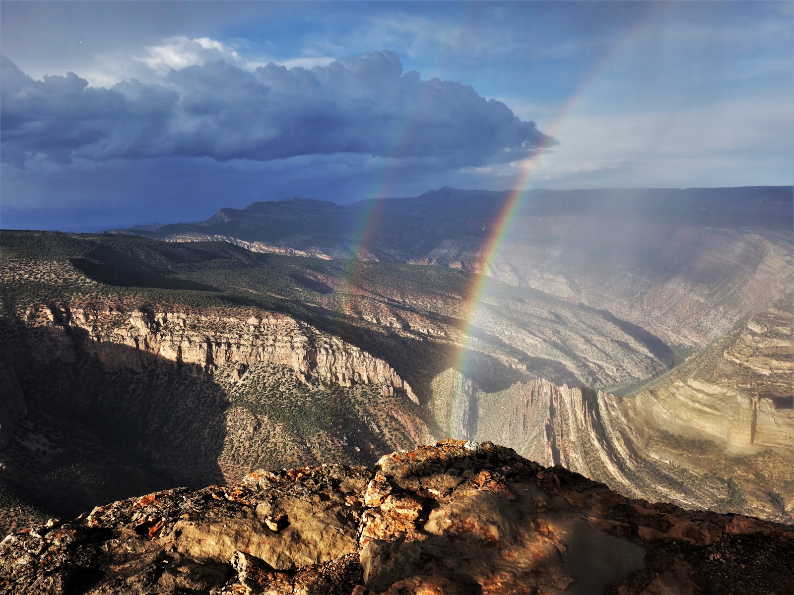
Just
as I got to the viewpoint it
started to rain, even as the sun remained bright in the west, and
sure enough
up popped a rainbow, more or less exactly along
the Mitten
Park Fault. Even the
Losers...
I was getting wet but I had brought my rain jacket. My
concern was for my camera and that maybe the rain was spoiling my
shots. I took some pictures from beneath a juniper but that provided
limited protection. I had started
carrying an umbrella to
waterfalls in western Washington and Oregon for
just such situations and one
still
laid buried somewhere in my car, but it had been a long time since
I'd given much thought to an umbrella on this trip. (Upon
reflection I recalled it was in December at Furnace Creek in Death
Valley, where a
lovely light rain had begun to contribute to that
locale's annual inch or two
of precipitation.
Quite
wittily, I thought, I went
into the gift shop and
inquired if they sold umbrellas. I was hoping for an appreciative
laugh – I get them now and then – but the gift shop clerks did
not recognize my facetiousness and
suggested I try the Furnace Creek Ranch Store.
Apparently it's hard to spoof the requests of the national park
visitor.)
 |
| Whirlpool Canyon, with raindrops |
 |
Overlook and Pinyon Pine
|
Soon
enough the rain subsided –
on the Harper's Point
Overlook at any rate; I
could see it
still falling in other spots across
the enormous vista
– so
I could take pictures with
less anxiety. The
problem now
was the rainbow. I was
done with this
ephemeral rainbow
and wanted to focus on the
timeless rocks,
but
instead of fading away
the rainbow
kept getting brighter. Then
there was a second and even a third over in Echo Park, though
technically I guess one
was the other end of the first one.
The
storm's light and dark were
exciting
but I never did get as good a composition as I
might have because
I was too distracted
by the
rainbow. It
occurred to me and not for the first time that a professional
photographer put in my place – one
never seems to be there -
would have cleaned up, not
distracted by the
commonplaces of rain
or rainbow though possibly
by thoughts of
what he or she would do with all
the money the
pictures would bring in.
Eventually
darker skies and ever encroaching thunder led me to declare victory
and head back to the car. On the drive I stopped one last time at the
Echo Park Overlook, curious as to whether the same rainbow could be
seen from there and the answer was yes, there they were, shooting out
of the ground like rockets. They really do have an objective reality.
Funny how it took me 62 years to learn that. The downpour held off
until I got back into the car, and I drove down across the Yampa
Plateau in dark spooky torrents.
4)
Dinosaur
National Monument is not a major hiking park. The longest official
trail and the only one in my hiking book is the Jones Hole Creek
Trail, so that was my next destination. This was another long drive,
45 miles, almost all of it outside the park across private ranches,
to the 5200' trailhead. Here Jones Hole Creek emerges newly born and
nearly complete from natural springs that issue up to 15,000 gallons per minute. The
instant creek then flows four miles down to Green River. It's a real
aberration in these parts, and a godsend. Native trout breed in the
creek and the Powell expedition had its first fresh trout dinner at
its mouth on the Green. Today
the Jones Hole National
Fish Hatchery uses the
spring water to raise over a million trout a year to restock lakes
and rivers of the upper Colorado River system, waters where natural
fish production was destroyed by dam building and other degradations.
The
four mile trail drops gradually alongside the creek and I felt like I
was floating. A boisterous creek, lush riparian vegetation, these
were things I hadn't seen since October in the Sierras. Compared to the places I'd been the past few months this was the Olympic Peninsula, the Elwha maybe, except for the enormous stratified towers rising up on both sides. A group of
four fishermen shadowed me for a while but soon they found their
places along the stream. I went on, moving so smoothly and happily
that I hiked straight past one of the trail's features, a wall of pictographs and petroglyphs, even though I spotted the sign indicating them. I
figured this must be some lesser display, as the real ones were
two miles in and I just couldn't consider that I'd already gone that
far.
 |
| Jones Hole Creek |
 |
| Jones Hole Creek |
In
another mile or so the valley opened up and the canyon walls rose even higher above a lightly wooded meadow. I spotted a Bighorn sheep, an
ewe, across the creek. It didn't seem too concerned with me. Down
near the Green the trail broke off into several directions and signs
expressly directed day hikers to follow one specific path. The other
trails led to boater camps and I guess they didn't want us low-rent
hikers bothering these more lucrative guests. I came upon two boaters
coming from the day hiker beach (I guess the segregation only runs
one way), and they were expressing concern with the state of the
trees. Box elders they said, and they seemed to know, with too many
dead branches, the damage, they hypothesized, incurred by beavers.
They asked me about downed branches on the hike down but having never
been there before I really couldn't say. Nothing compared to hiking
Deception Creek in the Alpine Lakes Wilderness before the trail crew
comes through, I knew that much, but that was no help. They suggested
I come look at the situation in their river camp. I said I might a
bit later and continued to the hiker's beach.


Here
the Green River was stuck deep in a huge but wide canyon, the very
Whirlpool Canyon I'd looked down upon from Harper's Point. I wasn't a
whole lot more than a swan dive from a spot that was some three hours
away by car. I found some shade on the sandy beach and it did indeed
feel like a beach. A cool breeze on a warm day, the river, quite
muddy thanks to the Yampa, rippling in what looked to me to be not
whirlpools but small steady waves. I wished I had brought a book as I
didn't want to hike back so soon in the heat of the day, so in order
to spend some time I wrote out some baseball analyses that had been
rattling around in my head lately every time I ate breakfast.
 |
| Green River - Whirlpool Canyon |
 |
| Green River - Whirlpool Canyon |
Then I
went to explore the boater camps, since I did have an invitation. I
found three nice shady camps, all deserted. They were numbered 2
through 4 so I surmised camp 1 was set on the other side of Jones
Hole Creek, which I didn't feel like trying to ford. I found what I
really wanted to see, the creek mouth, at Camp 2. Beavers had built a
dam so the creek was backing up, and humans had breached the dam just
enough to keep the creek from turning into wetlands. But the most
exciting part was, yes, the confluence. The crystal clear spring-fed
creek hit the muddy Green and stopped, visually, like a wall. It was
the most distinct demarcation I'd ever seen. The most distinct
imaginable.
 |
| Boaters Camp Jones Creek Hole |
 |
| Confluence of Jones Hole Creek and Green River |
 |
| Jones Hole Creek - Green River - Whirlpool Canyon |
 |
| Beaver Dam - Mouth of Jones Hole Creek |
The
hike back was a bit slower and hotter, but still very fine. I figured
if I was ever in this area again I would descend later in the day so
as to come back in the cooler late afternoon. One of the boaters I'd
met earlier was hiking back toward the river. They were in fact at
camp 1 and had the day off before a big day that would take them to
take out at Split Mountain Campground. She said she'd come upon three
bighorns in the meadow a bit up the trail, including a big male that
wouldn't bother moving out of the way until one of the females
started following her (the hiker), at which point the male got up and
intervened. I would have loved to come upon that crowd but they had
dispersed by the time I got to the meadow. No more bighorn for me. I
had to settle for the pictographs I'd missed on the way down, and
they were quite good, featuring not just a bighorn but a two-legged
with an exploding head. I was back to my car for an early dinner. A
sign at the trailhead had estimated round trip travel time for the
hike as 3 to 8 hours, my kind of range. I had taken six and would
have been happy to make it eight if only I had brought a book.


5)
For
my third and final Dinosaur expedition I drove 140 miles to the Gates of Lodore, a far-flung outpost of the national monument,
used primarily as a put-in for boaters to run the Green River. This
at least was a one way trip, as I would be leaving Dinosaur from
there. The Gates of Lodore are the entryway to Lodore Canyon, which
runs for seventeen miles under walls up to 3000 feet high. Like so
much of Dinosaur, it was named by the Powell Expedition, after a poem
called The Cataract of Lodore by Robert Southey, a favorite of
Powell's. Jack Sumner, one of the more grizzled crew members, opined
in his journal that naming the spectacular canyon after such “musty
trash” was “un-American, to say the least”. I don't know if he
was a shrewd critic or a no-nothing, but he just might have been
cranky. The expedition had suffered disaster on its first day in the
canyon, wrecking one of their four boats on the first major falls
they encountered, losing a good portion of supplies in the process.
Sumner proved heroic that day, rescuing the shipwrecked and
recovering valuable supplies. He could very well have been disgusted
that he had joined an expedition that seemed more facile with British
literature than with running rivers.
The
campground was empty except for one site which had one tent, two
trucks, and no people. The toilet door featured a suite of warnings:
this was bear country, sure; there
was an active mountain
lion in the area,
well…; plus a rabbit in the
campground had tested positive for Tularemia,
a new one on me but a
familiar story – rodents carry it, insects spread it, potentially
fatal to humans but treatable with antibiotics.
The sign advised
against handling rodents, their droppings, or their saliva – I
figured I could manage that -
and also to avoid insect
bites - impossible. Camping
full time I'd have to poison myself with Deet. In
fact I don't use any. I wear
long pants and a long
sleeve shirt even while
hiking and that will have to do. For ticks I tuck my socks up into my
pants and try to avoid tall
grass. I have no one to check
for ticks on my trickier parts and I don't really bother checking the
easier parts. I've never had a tick as far as I know, though
as far as I know I could have three on the back of my skull right
now. I could
maybe deploy a mirror.
This
portion of the park has only one official trail, a short climb to an
overlook of the Gates of Lodore. I walked it twice on Sunday night,
enjoying fine riverscape though the overview provides only a
mid-distance view of the canyon. To fully appreciate this place you
really do need a boat. From
somewhere around where I stood, Powell viewed the canyon at
noon and called it “a
beautiful portal, to a region of glory”. The
night before entering it though, he
called it “a dark portal to a region of gloom”. Echo
Park Dam would have flooded the Canyon of Lodore;
Flaming Gorge Dam tamed it from upstream. The
canyon was no longer the wild imposing one the Powell team
encountered, though with contemporary
nicknames such
as “Hell's Half Mile” it
must still be a beaut.
A
park nature guide told me mostly what I already knew about the common
high desert plants. It also pointed out some very old rocks along the
river. It didn't mention the
cadaver lying just off the
trail, an
ungulate - bighorn sheep,
deer, I couldn't tell. It
was all fur and bone, no meat left
to attract a cougar, so
I felt comfortable enough
walking by it though
I found myself looking over my shoulder a couple of times at the
overlook.
The
campground was as quiet and dark as any I've ever experienced. I
would have stayed a few nights just for that but there wasn't a heck
of a lot to do there. It's mostly a place for river runners and there
were no river runners there that day. The campground host told me
most boaters were running the wild Yampa, still running high with
spring snow melt. They'd switch to the Green when Flaming Gorge Dam releasd more water into the Green as the Yampa's seasonal flows
diminished. This is no trivial matter to river runners, and the dam's release schedule was posted on the ranger
station door.
The
occupied site remained people-less through the evening and I was
wondering what they had found to do. As dark settled in they still
hadn't arrived and I concluded they were running the river, with a
third vehicle to bring them back to their tent (which in retrospect
makes little sense but I wasn't thinking all that hard about it).
I
was sitting in my camp chair in near total darkness looking at the
stars when a bright light appeared on top of the ridge enclosing the
campground. At first I thought it was plane but soon I realized it
was ground level, hikers descending one very steep slope in the dark,
though wielding a killer lamp. Aha, the missing campers, either very
skilled or very foolhardy, I didn't know which. My curiosity got the
best of me, so when they finally got to their camp and got a fire
going I wandered over to more or less find out which it was. Skilled.
They'd been out two nights, were well equipped, and had descended the
slope on an old wagon trail they knew, one I'd walked by without even
noticing.
Another
car showed up a bit later (dark, empty campgrounds can be so
dramatic). These late arrivals made no noise and the next morning I
could see they had slept in their car. Eventually two guys got out,
donned packs and headed out, way too prepared for the little overlook
trail. One of the backpackers I had met the night before told me the
two new guys were heading into the bush in search of a treasure left
somewhere in the woods by someone who believed he was dying of cancer
and had published a poem that provided clues to the treasure's
whereabouts. This was apparently a well-publicized phenomenon; my interlocutor told me the state of New Mexico had estimated 40,000
hikers had come to the state to search for this treasure. I had just
spent a month in New Mexico and heard nothing about it, score one for
keeping to myself. Back in civilization I looked it up and found out
the man's name is Forrest Fenn, the treasure worth over a million
dollars and its location “north of Santa Fe”. In June 2020 someone found the treasure in Wyoming. Fenn died three months later, at the age of 90.
The
morning was lovely. No marauding ground squirrels, just poison
rabbits and a good supply of birds, including a beautiful small
yellow one I don't believe I'd ever seen before. (Yellow warbler?)
The river put me in a reflective mood. I walked the Gates of Lodore
Trail three more times waiting for the red cliffs to achieve their
morning glory. On my third pass the
voluble camper
asked me if I'd noticed the
carcass.
He told me the ranger said it
had been
an elk and that four or five more, including a huge bull, lay dead at
the bottom of the cliff. Active mountain lion indeed.
 |
| Green River |
 |
| Green River |
 |
| Green River (yes, I do like reflections) |
 |
| The Gates of Lodore |
 |
| The Gates of Lodore |
2 - I get most of my information on John Wesley Powell from Wallace Stegner's very great Beyond the Hundredth Meridian. The book also contains an account of the feud between Cope and Marsh.
3 - Ralph Lee Hopkins - Hiking the Southwest's Geology