Organ Pipe Cactus National Monument, January/February 2018
Driving south from
Phoenix toward Organ Pipe National Monument I heard on the news that
a man had been arrested in southern Arizona for harboring two
migrants who had illegally entered the US from Mexico. The man was
active in No More Deaths, a group seeking to save the lives of
migrants who were so frequently dying from exposure and dehydration
while crossing the Sonoran Desert. Mostly the activists were placing
food and water along migrant routes, not a crime but apparently an
affront to Border Patrol agents who frequently responded by
destroying these survival supplies. Border Patrol claims it does not
sanction or promote this practice, but the arrest occurred the very day No More
Deaths had posted a video of Border Agents destroying food and water
caches. The agency's claim that the timing was pure coincidence
seemed to stretch credulity.
The news report
struck me surprisingly hard. I had read about No More Deaths in A
Great Aridness by
William deBuys and
I felt
support for their radical
humanitarian efforts. And
the arrest took place in the town of Ajo, the nearest real
town to Organ Pipe Monument, exactly where I was heading. I would be
stopping in Ajo for gas and a few groceries in an hour or two, maybe
even driving right past the safe house where the arrest occurred -
Ajo is a small place. I would be also be passing the Ajo Border
Patrol Station, a harshly militarist-looking gated compound, and
would be driving back into Ajo at least once a week for resupplies
and mail, going through a Border Patrol checkpoint each time. In short, I
would be camping smack
in the middle of one of the
premier moral issues of our time and
doing exactly nothing but
living the leisured life of a retiree, however bare bones.
I felt
a wave of deep, I would say
existential, shame.
Cowardice? Impotence? Resignation?
Complacency? All of these are true. Complicity? That
one really worried me. Down
in the desert to dodge the cold, conveniently
setting my values and
convictions off to the side as I hiked about taking pictures,
attending ranger
programs, reading in whatever shade I could find. I had no answers to
any of this, no epiphany.
I knew I would not be giving
up what little I had to challenge Border Patrol down in the desert,
self-knowledge that
did not make me feel any better. I
would go about my way,
hopefully more attuned to
the fact that the life I was leading was not meeting a deeper need I
had discounted, apparently unconsciously.
II
The
organ
pipe
is a
lovely and distinct columnar cactus, its multiple
columns curving
upward and somewhat outward
from a common base,
resembling, when neatly
arranged, a pipe
organ, at least someone
thought. To
me they look more
like
a loosely banded bunch
of enormous
asparagus stalks.
Life is not always easy for
the cactus and sometimes the
arms appear to
flail about in what some see as a kraken-like organism.
 |
| organ pipe cactus |
 |
| pipe organ style |
 |
| kraken-style |
The organ pipe can grow up to 25 feet tall with as many as 100 arms though I've never seen such a beast. The biggest I've seen have been maybe twelve-to-fifteen feet high with thirty or so arms. Usually they're much smaller, as they are extremely slow-growing plants. An organ pipe cactus can take eighty years to grow to four inches in height. An organ pipe three feet tall could be twenty years old, and attaining its full height can take half a century.
Organ Pipe National Monument was established in 1937 to protect the only significant expanse of organ pipe cactus in the United States. Widespread throughout the Sonoran desert in Mexico, the organ pipe reaches its northernmost habitat in southern Arizona. It can tolerate just about any kind of heat but cannot stand frost for more than a few hours. Temperatures on the Organ Pipe desert floor rarely dip below freezing for more than a few hours, allowing both organ pipe to thrive there and me to camp comfortably there in winter.
Despite
its
top billing, the organ pipe
does not dominate the monument's desert floor. Visually
it is the
saguaro, the signature cactus
of the Sonoran desert, that
prevails.
(The saguaro
has its own namesake
national park outside Tucson,
a couple hours to
the east.) The
organ pipe is just one of an
array of Sonoran Desert flora
lightly covering these
alluvial plains. Palo Verde, a small tree with green branches and stick leaves; Ocotillo, a tall stringy whip-like plant, not a cactus but spiky all the same; a
variety
of cholla - teddy bear and
chain-fruit the most evident
to my eye; barrel cactus; the familiar prickly pear; creosote of course. Two
small trees, the mesquite and
the ironwood,
grow thick in
the washes. Trails from the
campground wind through this landscape, flat rocky terrain good for a
walk best saved for the
cooler morning and evening hours even
in mid-winter.


A number of hills punctuate the Organ Pipe landscape, and there the organ pipe reigns. It is particularly prolific on southeast facing slopes where sun-baked rocks hold daytime heat into the cooling evening and early morning sun strikes first following one of those rare freezing nights. Joining the organ pipe on these hills are thick clusters of teddy bear cholla, which can reproduce through cloning. Small ground-hugging cactus called hedgehog cactus also wedge themselves into these sunny, rocky hillsides.

Twin Peaks Campground has a lovely nature trail that winds up through a couple of these thickly-vegetated hills, providing vistas out to the mountains of Mexico as well as opportunities to learn the ways of the teddy bear cholla. Not only are they not to be hugged, they are to be given a wide berth. Seasoned desert hikers carry pliers to remove the barbed spines they receive from this cute and innocent-looking menace.


 |
| ocotillo |
 |
| ocotillo |
 |
| palo verde |


 |
| awww! |
Twin Peaks Campground has a lovely nature trail that winds up through a couple of these thickly-vegetated hills, providing vistas out to the mountains of Mexico as well as opportunities to learn the ways of the teddy bear cholla. Not only are they not to be hugged, they are to be given a wide berth. Seasoned desert hikers carry pliers to remove the barbed spines they receive from this cute and innocent-looking menace.

 |
| author (January 2009) |
Organ Pipe Monument shares a 33-mile border with Mexico, for most of its history a quiet one. The 1990s saw a dramatic increase in illegal immigration and drug trafficking across the monument, apparently a result of crackdowns in the more populated stretches of the border. The National Park Service reports that over 200,000 undocumented immigrants crossed monument lands in 2000, though how they got that number I don't know. The remote park became a scene of border havoc, cars crashing through the simple fence and racing pell-mell across the desert. After a park ranger was killed pursuing traffickers in 2002 the park service closed over half the monument's 330,000 acres in order to address security concerns.
Over the next several years the federal government installed a 30-mile vehicle barrier and a 5.2-mile pedestrian fence; increased the number of law enforcement rangers from 5 to 20; upped the Ajo District's border patrol from 25 agents to over 500; increased the agents at the Lukeville Port of Entry from 12 to 32; and installed towers with radio imaging technology to help track and apprehend illegal smugglers and other potential evil-doers.
 |
| pedestrian fence |
 |
| pedestrian fence, vehicle fence, Mexican neighborhood |

Twin Peaks, the
monument's main campground, sits five empty desert miles from the
border. Its a big campground
– 208 sites – largely
the domain of RVs. The
southernmost
row of
sites is restricted
to
tents and small campers so there
I was, my chair
turned
away from the RVs, gazing
out over the beautiful
desert,
the
city lights of Soyinto
glowing
after dark.
I
joke
about being the first line of defense against
the bad hombres Mexico was supposedly sending our way, but
I've never heard
of migrants or drug traffickers approaching the campground.
Their primary goal is to avoid being detected.
The campground isn't a total bubble. In January 2017 I saw a helicopter swerving in and out of the cactus barely above ground level, presumably chasing someone (unless the pilot was just practicing). This January I watched as one helicopter probed the summit of Twin Peaks, the prominent peak that gives the campground its name. The pilot was checking each nook and cranny apparently looking for someone, though I couldn't understand whether the agents had tracked someone up there or were just conducting a random inspection. I'd learn a little bit more about the likely motives later in my visit.
On one ranger-led nature hike I saw two park law enforcement rangers go racing into the desert in pursuit of a couple of unwanted intruders. An ironic benefit for hikers is the presence of hundreds of federal agents prepared for rugged mountain rescue. Plus water/rescue stations are placed throughout the monument's back country.


IV - The Hike
Organ
Pipe Monument occupies a typical Basin
and Range landscape, a number of small
mountain ranges rising to
envelop the desert
floor and the cactus-decked
hills. The Ajo Mountain Range
is the area's largest, running
north-south along the eastern border of the
monument several miles from
the campground. At
4808 feet, Mount Ajo
is the
highest
point of the range (the
campground sits at 1700 feet).
It is
my favorite
desert mountain hike, though
I haven't hiked
that many.
It's a tough hike, much tougher than its dimensions. The terrain is rugged, made up almost entirely of sharp volcanic rock and dangerously spiked plants. It demands concentration with nearly every step; if you stumble there is nothing to grab hold of and nearly nowhere to fall that won't cut you. The trail isn't always evident, the way marked by cairns that require a certain amount of route-finding and hopping about. There is very little shade, particularly toward the middle of the day.
It's a tough hike, much tougher than its dimensions. The terrain is rugged, made up almost entirely of sharp volcanic rock and dangerously spiked plants. It demands concentration with nearly every step; if you stumble there is nothing to grab hold of and nearly nowhere to fall that won't cut you. The trail isn't always evident, the way marked by cairns that require a certain amount of route-finding and hopping about. There is very little shade, particularly toward the middle of the day.
 |
| agave |
 |
| ocotillo |
 |
| juvenile organ pipe |
 |
| cholla |
 |
| barrel cactus |
 |
| agave |
A good portion of the day's elevation gains comes when scrambling up steep chutes of loose rock slippery as ball bearings. In addition to the ubiquitous trail side hazards, one of these slopes has an overgrown prickly pear cactus perched right at the bottom, seemingly placed by a sadistic trail builder. Sliding down into this cactus is a frightening possibility and without immediate medical assistance could very well be a death sentence.

Overall
I did well avoiding the
spiked
plants, only once forgetting myself and doing a northwest-style
breast stroke through some shoulder high foliage to the brief dismay
of my underarms. The two minor
wounds I did sustain came
from the sharp volcanic
rocks. The
first one came when I
stumbled
and caught my balance with my
hand, taking
a cut on the base of my left
pinkie, a hard place to keep a band-aid. The
second was
to the sole of my right foot.
I got a small stone in my boot and did
what I usually do which is try to walk it into a place where it
doesn't bother me. But
it
kept getting worse and when I finally sat to remove it I
saw that a
tiny volcanic pebble had
been plowing the skin off my foot the
whole time I moved
it around. More antiseptic, a band-aid, clean socks.
I
enjoy
the
challenges
of the trail but I'm not out
there just
to
take a beating.
The
terrain is
fantastic.
The
Ajo
Range
is
almost
entirely volcanic
in origin, though that
doesn't get to
the essence of its
attraction. I've hiked plenty
of volcanic landscapes and have never
seen anything like this range
of palette,
structure,
shape,
and even texture.
 |
| Mount Ajo |
 |
| Ajo Range |
 |
| Ajo Range |
Geologists
say that
a series
of eruptions extending from 22
to 14
million years
ago deposited
layer upon layer of
lava flows – mostly
andesite
and
rhyolite
–
leaving
behind
broad
bands of light and dark-colored rock,
subsequently
contorted
or folded by
Basin and Range faulting.
Ash
from the volcanoes fell and compacted
into
welded tuff,
exposed
now in colors
of buff,
yellow-orange, light-yellow,
greenish-yellow and white. The
flows are riven
by rhyolite dikes up to 230 ft wide (but usually much more narrow)
dipping steeply to the west. Volcanic
mudflows (lahars) are
laden
with pebble-to-boulder-to-block-size
rocks
-
conglomerates and fanglomerates “moderately
to poorly cemented, crudely bedded, and poorly sorted”,
meaning among
other things that it
falls apart easily. Massive
nearly vertical cliffs of
red-brown
rhyolite provide
most of the elevation. Steep
slopes, flat benches, and ledges abound.*
The language
is
wonderfully suggestive, though as
a
geologic
summary mine is largely meaningless. No one would
confuse me with John McPhee. It
could be that such a mish-mash is common to volcanic fields, and
that
this
scene
is distinguished mostly by
its nakedness.
No snow, little soil, and only sparse
foliage leave
it all just sitting
out there, ready
to
study. I
understand some of the terms
but
could
only tentatively correlate them
with
the
mountains in front of me. Welded
tuff I think I know. Loosely cemented conglomerate I would
come to know intimately.
I
missed the
northwest-trending dyke altogether but a geologist friend pointed it
out to me in
my photo.


 |
| Poorly cemented conglomerate> |

 |
| welded tuff? |

What
I did was pull out my camera to take a picture of the helicopter as
it flew directly over me. After all it was quite an unusual sight,
seemingly worthy of documentation. Plus I
thought it might signal to the pilot that I was a hiker, as a migrant
would probably not be carrying a camera. The sun was in my eyes and
my fingers couldn't find the right button so I missed the close up
shot as the helicopter roared over my head. I guess the agents saw
what they needed to see as the helicopter pulled up and away toward Mount
Ajo. I got a couple of shots of that, not nearly as impressive but
here you go.


The
incident raised for me the question of whether anyone hiking in the
park is subject to suspicion and it fed my growing concern that the
Border Patrol was an army out looking for an enemy. I was also
curious what they would have done if they decided I was an unwanted
person. The terrain was too tough for a landing. Would an agent climb
down a ladder or even risk some wild jump? Maybe buzz me into
submission like the helicopter I had seen buzzing the cactus? In all
I'd think a hardened trafficker might be able to evade agents in a
helicopter. But this was all speculation on what for me was an alien
situation.
As
I resumed my hike I began to question the wisdom of my camera tactic.
I sure wouldn't do such a thing on a city street, where my odds for
survival might be better than someone with darker skin but would
still not be good enough. I didn't think Border Patrol would gun me
down from a helicopter but I realized I might have pissed them off,
thinking I was documenting their activity rather than documenting a
rare phenomenon. The fact is I assumed the pilot was acting
legitimately according to his or her mandate, and it never occurred
to me I would be capturing much less revealing anything amiss.
But
I started to worry about my car. It was the only one at the trailhead
so agents could easily link it to me. I imagined them radioing down
to their colleagues to give my car a hard time and teach me a lesson.
This could border on paranoia, but it more reflected the totally
unknown relationship these forces have with the civilian population.
Maybe animosities were running higher than I knew. In any case my car
was intact when I eventually returned to it.
Later
in the week I approached a Border Patrol agent as he was wrapping up
his Visitor Center talk and I told him what happened. Do you check
out anyone hiking in the park? We can. Why would someone entering the
country be climbing a mountain? That's where they go. They want to
cross onto the adjacent T'ohono Oodham reservation because there we
can only pursue on foot. I told him about my taking a picture and he
said no I didn't want to do that. You don't want to go over to the
other team is how he put it. I assumed he was referring to his fellow
citizens who were monitoring Border Patrol actions. At least he
didn't say other side, but I still found it off-putting. I wasn't
about to pursue that with him.
Anyway,
the helicopter disappeared over the ridge and I resumed my assault on
Mount Ajo. The peak kept receding higher up and further away, a
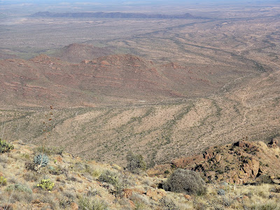
familiar trick of mountain summits, but I was in a wonderful place. Views from atop the highest ridge were spectacular. Basin and Range mountains are both isolated and narrow, so views open in all directions. Views back over the monument were great.


But the views to the east out over T'ohono Oodham Nation - a map-like perspective of dirt roads, intersecting washes, and sharp eroded hills - were my favorite part of the hike. Endless miles of Sonoran desert stretch down to Mexico - no border in sight - raising for me the question if the migrants want to get to the reservation why don't they just cross the border down there.


But the views to the east out over T'ohono Oodham Nation - a map-like perspective of dirt roads, intersecting washes, and sharp eroded hills - were my favorite part of the hike. Endless miles of Sonoran desert stretch down to Mexico - no border in sight - raising for me the question if the migrants want to get to the reservation why don't they just cross the border down there.


The
flora at this elevation was far more
lush
and closer to spring, indicative of sky-island ecology. Several plants were new to the hike; juniper
and jojobe
were
two I recognized. I passed through the gauntlet of ocotillo I recalled from the first and only summit of Ajo, in January 2009.
Some rock
scrambling
was
required to reach the summit.
The
peak itself is composed of this strange yellow surface
pitted with large multi-colored rock. Communications
equipment of unknown function sat
on top.
 |
| Sky Island Flora |
 |
| Ocotillo gauntlet |

 |
| poorly cemented conglomerate? |
 |
| Mount Ajo Summit |
As
I sat and rested on the peak I found myself finishing off my water,
not
a good
thing, particularly
since I still felt parched.
I
had
drank
water
before I started and
brought two liters with me but
it was
not enough.
It
was a hot
day but
not that hot,
peaking maybe at
80 degrees, the
heat mitigated by a light
mountain breeze though
there was no
cloud cover and nearly
no shade.
I
figured it was all downhill
from there
so I should
be all
right. I was not, and
I got into trouble pretty
quickly. After
working to capture a
wonderfully minimalist rock garden display, I headed
out onto
a broad rock bench extending
from the steep mountain wall.
It didn't
seem familiar but it was the only way to go as far as I could tell. I
immediately encountered
a confounding sea
of ocotillo and concluded
it was the ocotillo
gauntlet I had passed on
the way up, though I didn't
remember them being so closely bunched or
on such
steeply slanted ground,
covered with loose volcanic
pebbles.
Avoiding puncture while not slipping and falling down hill entailed
tricky balance and some
intense concentration which I
managed if barely.
 |
| wonderfully minimalist rock garden display |
Next
came a drop
down about five feet - do I
remember climbing up a five foot bench on
the way up? I
sat down on the ledge in
order to scoot down and
I gave
a tug at a small boulder protruding
from the bench
to see if it would provide
any support. Instead it
came ripping out of the ground and crashed
to the floor below, bringing large amounts of rock and dirt down with
it. OK, loose
rock (poorly cemented conglomerate) - good to know. The
drop was easy enough so
I followed the
ledge to its end and saw
that it went nowhere. There
was no sign of any trail
anywhere on the ground below. I must
have missed something. I'd
have to go
back the way I just came.
First
came the five foot ledge. Normally I would have lifted myself up the
rocks that appeared to be entrenched in the adjacent wall but I had
just determined their weakness. Still I gave a small boulder a tug
and once again it ripped out of the wall taking half the hillside
down with it. I could have spent the rest of the day just pulling
this twenty million-year old mountain apart. Once up the bench I had
to re-face the treacherous ocotillo maze and this time the
concentration it demanded was more than I could muster. For a few
endless moments I just stood there nearly paralyzed. It was
challenging but not extraordinary; I just lacked the wherewithal to
take it on. It was only then that I realized something was wrong with
me. My brain was not functioning properly. I was suffering from
dehydration.
Somehow
this realization gave me the fortitude to negotiate the ocotillo and
I was back to the minimalist rock display, where I'd last known I was
on the trail. I immediately spotted a small ground cairn indicating
the trail cut rather sneakily down a narrow slope to my left. The
cairn was too small and too low for such a significant turn but I had
only myself to blame. I was on an unmarked trail that required route
finding and I just blew it. The important thing was I was now aware
that I was mentally compromised and could not trust my own judgement.
No more of my “it's gotta be this way” instincts, which are
generally pretty good, or at least do no lasting harm. I would have
to take each turn very carefully, stop and consider my options, and
stop taking so many damn pictures.
Sometimes
when I'm hiking and things get a little difficult I start playing a
little game in my head, or rather it starts playing itself in my head
regardless of what I think. It is some sort of sub-conscious focusing
device and I've been doing it for a long time. I am a participant in
some kind of hiking competition in which I am being scored for length
and difficulty of hike, plus style and panache. Somehow I am being
observed by sportscasters, one of whom happens to be Lou Piniella for
reasons I can't begin to imagine. Lou is my coach. He is addressing
my progress, health, safety, judgement and so forth. “He's moving
carefully. His ankle is a little sore but he's been through this
before.” Like that. I am far from a first-tier performer in this
competition but I am dogged and occasionally capable of posting some
scores that can help the team, whatever the team is. Lou has stuck
with me even as age slows me down.
On
this hike a second commentator was on hand, a woman – I have no
idea who she might have been. She was more of a physical therapist,
evaluating my condition diagnostically and reporting with candor:
this guy is very tired, dehydrated, not thinking clearly. With a
guarded optimism she thought my chances of making it back were only
good. (They've got me physically monitored but are unable to actually
intervene.) I took her prognosis to heart and proceeded carefully,
resting often. I started feeling a little better as the day cooled
and the mountains began casting more shade. I even resumed my shutterbugging ways.


It was dark by the time I got back to the trailhead. The final
stretch through the thick bottom washes were the most tense. If
anyone was going to pop out on me this would have been the time and
place. Migrants lingering near the trailhead? (I had food and water
there; I could actually help them). Traffickers looking to hijack my
car? Pretty unlikely; they need to stay off the roads. A couple of
Border Agents bursting out of the brush demanding I drop? None of
this happened.
Normally I'd have had dinner at the trailhead picnic
table but this was far from a normal situation. I still had a good
ten miles of dark dirt road to drive. I couldn't see the road surface
very well and I sure didn't need a flat tire so I stuck to my prudent
10 MPH and it took an hour. Toward the end of the drive a Border
Patrol vehicle came racing up from behind. It did not flash its
lights so I just kept going while it cooled its heels behind me. At
some point it lost interest and fell back into the dark.
V
With
every visit to Organ Pipe (this was my third) I have been taken by
the long view of the Ajo Range from the campground. The sea of
saguaro, the intervening hills, and the line of jagged peaks make for
a very attractive scene, particularly in the early morning and late
afternoon. It is too far away for a good picture though, so I finally
decided to go in for a closeup. I could spend two hours driving the
one-way Ajo Mountain Road, or I could just walk a few miles directly
across the desert. It was a lovely day for a walk so I set out on
foot in mid-afternoon, with the goal of finding a good location near
sunset.
Walking
cross-country on national park land is usually a liberating
experience but at Organ Pipe it is fraught with issues. I wondered if
Border Patrol had me in its sights. I hadn't yet learned about the
ground sensors they use and even now wonder if they deploy them on
national park ground. I wondered if they did spot activity would they
come out and get me. Do they really track down anyone they detect
walking through the national monument? I also wondered if I'd come
upon a migrant or two and how that might go. I had no food and not
that much water so I wouldn't have been much help to them. And of
course I wondered about the drug traffickers, if maybe they had me in
their sights. I figured that both migrants and traffickers were
trying not to be seen and being sharper-eyed than I would likely
avoid me. In fact the only unusual thing I saw was an abandoned
backpack badly weathered and I certainly wondered what happened to
its owner. It was indeed a wondrous walk.


The
terrain itself wasn't all that different from the trails radiating
from the campground except the flora was thicker this much closer to
the mountain drainage. Some of the washes were so thick with
vegetation I had to pick a spot to crash through, choosing the sharp
branches of the ironwood or palo verde over their spiny cactus
neighbors. There was no trail to follow but I was heading straight
toward some easily identifiable peaks so navigation wasn't a problem.
The further I got the more the perimeter hills blocked my views of
the mountains, diminishing the panorama I sought. I always forget
about that. I thought the rocky hills might be loose alluvial fans
but this did not seem to be the case. One in particular was clearly a
volcanic deposit.


My
intention was to intersect the Ajo Mountain Scenic Drive and I did,
right near Exhibit 17. I was too early for good light so I proceeded up the narrow dirt road further toward the mountains. It was a
lovely Sunday afternoon and a half dozen or so cars drove down the
road in my direction. I stepped up and out of the narrow entrenched
road but kept myself conspicuous and everyone waved, satisfied I guess
that I was not a social menace, just some addled old guy out for a
hike where nobody else hikes.
I
wanted to make it to a viewpoint I knew that provided great views out
to Diaz Peak - Exhibit 16 maybe - but my geography was a little off.
After a mile or so of flat road walking I got to Exhibit 16 and it
was nothing at all. I did enjoy some good flora along the way. The
saguaro in particular can take on some strange shapes and I found a
couple of good ones, including one strangling an ocotillo. I was
denied my envisioned photo, though, as sunset was approaching and I
had to start heading back.


I
knew all along I was not going to try to find my way back through the
open desert at dusk. I would have to return along the road, a
roundabout way adding an extra couple of miles to my hike, the hard
dirt surface much tougher on my feet than the soft desert floor. But
I had the feeling I would not have to walk for long. I wasn't
absolutely counting on it but I was willing to bet that once dusk set
in a Border Patrol vehicle would check me out and probably give me a
ride.
The
first two cars that passed me in the dimming light were noticeably
less friendly than the ones I encountered in full daylight: no waves,
averted eyes. The third was a red pickup with an ORV in the bed and
that driver did take a look at me though he did not wave. The fourth
vehicle was Border Patrol. The agent stopped alongside me and asked
me how my hike was. I said it was maybe a mile or two longer than I'd
have liked. Would I like a ride? I would, thanks.
He
went to some trouble to make space for me in the front seat and
offered me water though I still had some of my own and we had a
friendly little chat along the way. He asked about my hike and I
mentioned my sore feet from the hardened road. He said it was good I
didn't return cross country because the drug traffickers were out
there. I laughed and said “C'mon, you guys have this place covered
like ants.” This animated him. “They know where we are”, he
said. “They're watching us. We listen to them talking about us on
the radio.”
This was the first time I'd heard what I've heard
several times since: the traffickers place sentries up in the
mountains to monitor and report on Border Patrol movements. The
sentries might be up in a mountain for weeks, traffickers sending in
resupplies, a more sophisticated and also more brazen operation than
I'd envisioned. So that was what that helicopter was up to that
morning at the campground trying to poke a hole through Twin Peaks.
Looking for sentries. And I could have been one going up the Ajo Peak
trail, though I still don't know how they might conclude that I
wasn't.
He
took me to the Visitors Center and asked me if that was ok. The
campground was still over a mile away but he seemed relieved when I
told him I was good. I think all parties prefer that Border Patrol
yield the campground area to the park rangers. As I walked away from
his truck I saw the red pickup that passed me wave him down and
presumably report me, as I heard the agent say “I just dropped him
off. He's right over there.” The pickup drove by me on the road and
asked if I wanted a ride. “I'd rather die here on the ground” is
what I'd like to have said but I just shook my head no.
 |
| Shameless sunset |
 |
| Totally Shameless Sunset |
* Interpretive Geologic Map of Mt Ajo Quadrangle, Organ Pipe Cactus National Monument, Arizona
by Janet L. Brown (USGS Open-File Report 92-23, 1992)
by Janet L. Brown (USGS Open-File Report 92-23, 1992)