Since I was
spending the summer in the Cascades, Puget Sound people could meet up
with me to go hiking. Two people managed to overcome the
communication and logistics issues to do so: Anna Clark in mid-August
and Anje Monte Calvo in mid-September, nicely bookending my
abbreviated Cascades summer.
I – August 11, 2016 - Hidden Lakes
Peak – Mt. Baker Snoqualmie National Forest
Anna and her five-month old puppy Riley met me one morning at Marble Creek Campground along the Cascade River. Anna drove us up the steep narrow dirt road to the Hidden Lakes trailhead while I provided valuable advice and admonition from the passenger seat. The road got us to 3600 feet on Hidden Lakes Peak, more than half way to its 6900 foot summit. Not that we expected to summit. The primary destination is the 6600 foot saddle overlooking Hidden Lakes. I didn't know if we'd make that, but the hike is pretty great at any other number of intermediate destinations, so I felt confident we would have a good day.
 |
| Riley |
 |
| Anna |
Out of the forest,
we entered the meadows of Sibley Creek, the heart of the climb.
These meadows are outstanding, as lush and green as any Cascade
meadows I know. They are also very steep - what are known as vertical
meadows – as well as one of the more consistently fly-ridden. My
usual strategy is to hit this trail early, while the flies are still in their pre-swarm strategy meeting. But Anna had driven all the way
from Lynwood so the flies were ready for us. They were particularly
attracted to Riley, at times nearly engulfing him. His main defense was to eat them.

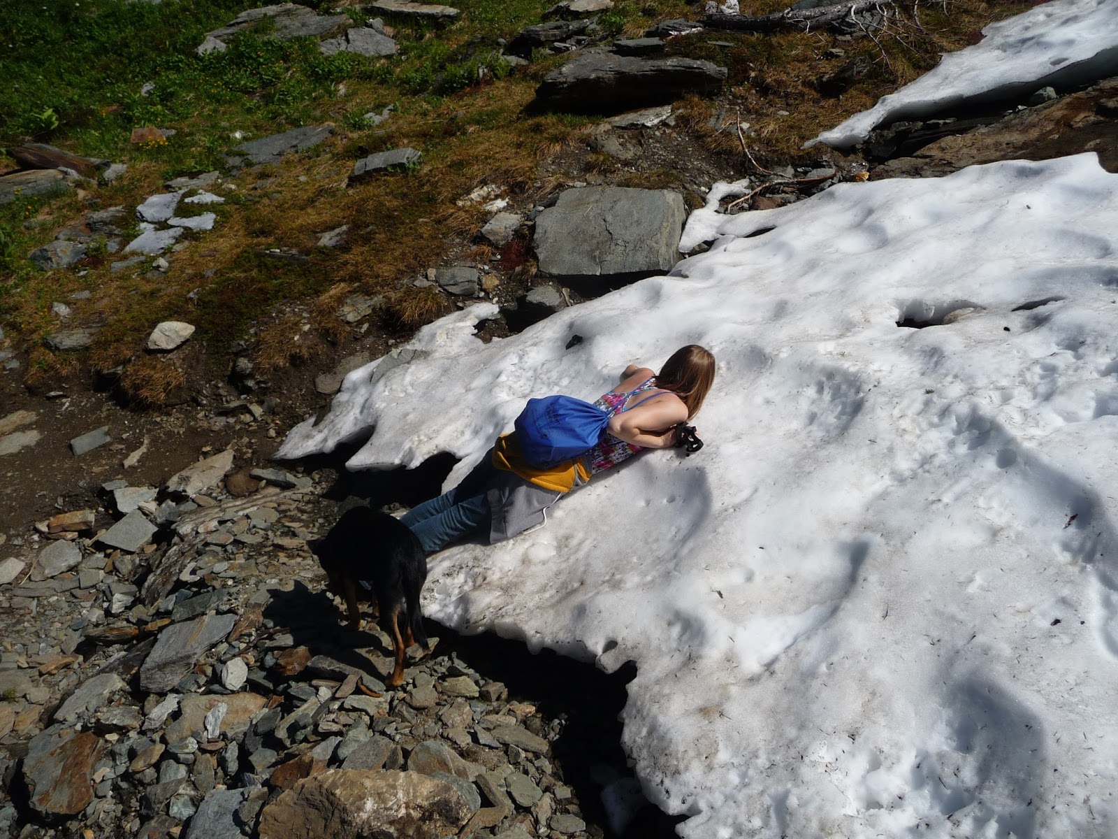
The slopes are also relatively shade-less, and it was a hot day. The combination of steepness, heat, and flies posed a challenge. When we tried to rest in what little shade there was the flies made it unbearable, forcing us to resume climbing quicker than we'd have liked. The lack of optimal rest took its toll, and Anna began to flag. It was way too soon to quit so I spotted a small snowfield up at the top of the meadows and declared that to be our goal. Actually my goal was much further, but if we didn't get to the first goal we sure weren't going to get to mine. I'm not sure Anna even saw the snowfield I was pointing to, as when we got there she seemed surprised and delighted, immediately collapsing onto its cooling mass. Riley was more circumspect; he'd never seen snow before. He approached it cautiously, leading of course with his nose, and upon contact shot backwards 15 feet like I'd only seen before in cartoons. It was hilarious. But he got the point quickly enough and was also finding relief and refreshment on the icy oasis.


 |

The slopes are also relatively shade-less, and it was a hot day. The combination of steepness, heat, and flies posed a challenge. When we tried to rest in what little shade there was the flies made it unbearable, forcing us to resume climbing quicker than we'd have liked. The lack of optimal rest took its toll, and Anna began to flag. It was way too soon to quit so I spotted a small snowfield up at the top of the meadows and declared that to be our goal. Actually my goal was much further, but if we didn't get to the first goal we sure weren't going to get to mine. I'm not sure Anna even saw the snowfield I was pointing to, as when we got there she seemed surprised and delighted, immediately collapsing onto its cooling mass. Riley was more circumspect; he'd never seen snow before. He approached it cautiously, leading of course with his nose, and upon contact shot backwards 15 feet like I'd only seen before in cartoons. It was hilarious. But he got the point quickly enough and was also finding relief and refreshment on the icy oasis.


As it happened (well, I had known it already), the snow was where the steep ascent gives way to a long but much more temperate crossing of a high ridge across the front of the mountain. The flies also started to thin out at this point. As I had hoped, the respite provided us with new life and we strolled the ridge with greater pleasure. The views had been pretty great for a while but became increasingly spectacular, with wave after wave of mountain emerging in view the higher we went. First they were green with meadow and timber, then rocky and jagged, finally glaciated, the latter extending as far as the eye could see. Mount Baker, appearing early in the mid-distance, and El Dorado Peak, emerging somewhat later, were the highlights, but the sheer number of peaks, too many to name, was the best part, in my opinion.


This stretch of trail entailed more climbing than I'd remembered and it gradually became clear we
weren't going to get all the way to the overlook of Hidden Lake. I
held out for one last snowfield, and there, with a view of the fire lookout on Hidden Lakes Peak's lower summit, we declared victory. One
companion reclined in the flowers, the other pranced about in the
sunny snow. I was happy enough with our achievement. I realized
that though we did not get to the hike's “official” destination,
we had attained a terrific destination unto itself, for Anna and Riley's first
mountain hike.


The highlight on
the descent came when we got to the creek that Anna had dropped Riley
into on the way up. Seemingly recognizing it, Riley burst out ahead
and led the crossing, picking, I noticed, the very best place to
cross. We got back to the campground and had dinner at the picnic
tables among some big leaf maples. I served Progresso Chicken Noodle
Soup; I always serve Progresso soup. I should get promotional fees
from Progresso Soup. Now Anna has access to homemade soup every day
at work, so after eating her chicken, noodles and carrots, she passed
the salty broth onto the more appreciative puppy. We visited the
river and Riley did more prancing. Then off into the night they
drove, Anna anxious to get some snacks for the drive, leaving me to
worry their safe return.
II – September 12, 2016 - Panhandle Gap – Mount Rainier National Park
I was at Trout Lake recovering from my Mount Adams adventure when Anje and I finally made our plans. I spent most of a day driving the forest service roads back to Silver Springs Campground outside the northeast boundary of Mount Rainier National Park, where she could meet me and enter the park on my very important person senior access card. That evening, more friends – the Hobbes family – Judy, Rod, and Brian – stopped for a quick visit at my campsite on their way back from hiking on Burroughs Mountain. Judy had brought a gift - some dehydrated peanut butter I had been asking about, and I can say it is decidedly better than starving to death. They declined my offer of Progresso Soup.
Anje arrived early
the next morning and we headed to the Summerland trailhead. A Monday
morning in mid-September and the small parking lot was already filled: this is a very popular trail. I myself have probably hiked it more times
than any other trail. It begins with several miles of steady but modest
ascent of forest, switchbacks providing rest stops over rocky gorges of Fryingpan Creek. We crossed the creek on an ancient
footbridge and climbed some switchbacks through flower gardens
largely gone to seed by this time in the season. The Summerland
meadow presented a classic view of Mount Rainier and Little Tahoma
over golden autumnal meadow grass before the trail climbs a flight of
steps alongside a lovely creek lined with monkey flower and lewisia.
Summerland is small and we were in and out of it pretty quickly, entering the part of the hike that makes it nearly an annual hike for me. Beneath the daunting Meany Crest, a narrow bridge crosses a roaring creek just barely emerging from snow melt, leading into a rocky area that is free from snow maybe six weeks a year. Spring, summer, and fall come and go in a hurry, and tiny little flowers were still blooming. I introduced Anje to my favorite tarn in the whole world, and we dilly-dallied around it. Anje was much impressed by the color of the rocks, mostly green and pink. A couple of prize winning patches of moss added almost incongruent life. And that's just the ground. Looking up, the views rather stagger the brain. One of my favorites anywhere focuses on the spot where Emmons Glacier descends through lateral moraines to intersect the greenery of Goat Mountain, Burroughs Mountain providing backdrop. A bit later comes a view back to Little Tahoma and Rainier looming above the periglacier ground, my tarn very much included. This is also one of my favorites in the whole world. That's two in one hike.


 |
| Mount Rainier from Summerland |
Summerland is small and we were in and out of it pretty quickly, entering the part of the hike that makes it nearly an annual hike for me. Beneath the daunting Meany Crest, a narrow bridge crosses a roaring creek just barely emerging from snow melt, leading into a rocky area that is free from snow maybe six weeks a year. Spring, summer, and fall come and go in a hurry, and tiny little flowers were still blooming. I introduced Anje to my favorite tarn in the whole world, and we dilly-dallied around it. Anje was much impressed by the color of the rocks, mostly green and pink. A couple of prize winning patches of moss added almost incongruent life. And that's just the ground. Looking up, the views rather stagger the brain. One of my favorites anywhere focuses on the spot where Emmons Glacier descends through lateral moraines to intersect the greenery of Goat Mountain, Burroughs Mountain providing backdrop. A bit later comes a view back to Little Tahoma and Rainier looming above the periglacier ground, my tarn very much included. This is also one of my favorites in the whole world. That's two in one hike.
 |
| Anje |

 |
| Emmons Glacier, Goat Mountain, Burroughs Mountain |


Earlier in the
season the hiker winding up to Panhandle Gap can encounter a steep, dicey snow field, but here in mid-September we crossed a mere patch. At 6800 feet, Panhandle Gap is the highest point on the
Wonderland Trail. It also happens to be the hydrologic divide between
Puget Sound and the Columbia River, and the view opens to Mount
Adams, the Goat Rocks, and on clear days, including this one,
Oregon's Mount Hood. We had a nice lunch amid 360 degrees of
splendor. For many this is the final destination, but there's so much
more to see. The resident herd of goats, for example. I had asked
some returning hikers if they had spotted any goats and they had not.
Now this is as reliable a herd of goats as the one at Ptarmigan Ridge
and I concluded they had not tried too hard. So after unch I said to
Anje “Let's go find some goats”, and led the the way along a
narrow use trail heading east from the pass. We hadn't gone twenty
yards when Anje announced “there they are”. A huge herd, more
goats than I had ever seen here, were plastered quite conspicuously to the steep grassy slopes rising to the east.
 |
| Panhandle Gap |
 |
| Mountain Goats |
Apart from the goat herd, this sloping green meadow offers a tantalizing view from the top, where it ends abruptly at the shocking cliffs and spiraling
towers of the Cowlitz Chimneys and the still-imposing remains of
Savant Glaciers. From Sunrise these rugged glaciated volcanic plugs
comprise the snowy extension of Mount Rainier and Little Tahoma,
appearing accessible to only the hardiest of climbers. Yet from
Panhandle Gap they are a hands-in-pockets stroll, one very few people take. Usually I add this
stretch to my hike (or continue on down the Wonderland Trail to views
of the Ohanapecosh Glacier) but it had only been three days since my
Mount Adams ordeal so I was reluctant to overdo it. I told Anje I'd
be happy to wait behind if she chose to go, and to my surprise she
took me up on it. (She later acknowledged it was further than it
looked.) I was happy as pie reclining in this meadow: beautiful day,
light breeze, warm sun, no bugs, not another person around, while
Anje respectfully worked her way up and around the goats. I don't
know exactly what Anje saw up there as she had used up her camera
battery (Panhandle Gap will do that to you). But this is what I saw
last time I was there.


I was just starting to get restless when I spotted Anje came back with
a piece of goat's beard to show me (of course she left it there
on the meadow). We descended to Panhandle Gap and I was surprised to
find we were the only ones left, surprised until Anje told me it was
4:30. Rather late to be at Panhandle Gap in the middle of September,
we would need to hustle back to beat dusk. (We both carried
headlamps, but still.) So we hustled, sort of. We had to examine a
little reflective puddle at the base of a snowfield, say goodbye to
what I feel was the summer's best patch of moss, and stop to count a
small breakaway herd of goats making its way across the base of Meany
Crest. I'd never seen goats there and I wouldn't think it would be
such a receptive habitat, but I have to trust the goats know what
they're doing.


We made good time dropping down through the woods, a little better time than my knees would have preferred. Each drop down hurt, a pain I registered with a manly yelp. But the fact is I was encouraged. This wasn't the pain of injury, this was pain of sixty-two year-old knees hiking downhill too quickly at the end of a long day. Anje said her knees were hurting too though she suffered more silently than I was managing. Finally, not in response to anything she said, or for I know was even thinking, I said what needed to be said, which was “Listen Flynn, either shut up about your knee or quit hiking!” (I wonder if maybe I was channeling Wesley). And I did, shut up about my knee that is, and we talked about BBC Mystery the rest of the way down. Though the park service seemed to have tacked an extra couple of miles to the trail we eventually got back to the campground, where I served Anje some Progresso Minestrone soup before she took off on her dark drive back to Seattle.


We made good time dropping down through the woods, a little better time than my knees would have preferred. Each drop down hurt, a pain I registered with a manly yelp. But the fact is I was encouraged. This wasn't the pain of injury, this was pain of sixty-two year-old knees hiking downhill too quickly at the end of a long day. Anje said her knees were hurting too though she suffered more silently than I was managing. Finally, not in response to anything she said, or for I know was even thinking, I said what needed to be said, which was “Listen Flynn, either shut up about your knee or quit hiking!” (I wonder if maybe I was channeling Wesley). And I did, shut up about my knee that is, and we talked about BBC Mystery the rest of the way down. Though the park service seemed to have tacked an extra couple of miles to the trail we eventually got back to the campground, where I served Anje some Progresso Minestrone soup before she took off on her dark drive back to Seattle.

Thus ends the “Take
Care of Your Knees, That Might Work for You” segment of my story.
You won't hear another thing about my knees, at least through the date
of this posting – December, cheez! (They're doing just fine.) This leaves me without an organizing theme for my subsequent stories. Have
I mentioned my painful rotary cuff
Did I mention that our new dog just had knee surgery?
ReplyDelete- Anje
Good news. How's that weight problem going?
Delete