Occasionally my tour director would lose control of events. It happened on my birthday in fact - my 55th since you asked. The day started off well enough. I got an early start for the trailhead, not for fear of lightning - I would be hiking the low-elevation East Fork Jemez River Trail - but to avoid being soaked in an afternoon rain. Also I wanted to begin waking up earlier than I had been doing in preparation for summer hikes in the Rockies, when afternoon lightning would be a concern.
I parked at the Jemez Falls Picnic Area and walked down to the falls, which were modest indeed. I then set off along the East Fork Trail, through broken forest: boulders, outcrops, old trees, down trees - the real messy deal - all in great early morning light. But in less than a mile the trail crossed the highway and became a wide duff-dirt surface through a recently culled second-growth ponderosa pine monoculture. Fine for bicycles but a bit dull for hiking, though the open forest allowed a good look at a wide variety of flowers.


The trail got narrower and so did the trees and soon I was brushing through aspen and brush. Tick country I figured, not that I checked. But after a couple of miles of this the trail dropped to a sweet river bottom, flowery and lush. Very popular as well; I had to duck into the woods to avoid a thick clump of some 25 social hikers. The bucolic little river runs alternately through open meadow and along volcanic cliffs, the latter making for some intriguing reflections of water on the rock.


I followed the trail to its end at another trailhead along the highway, the one to use if you just want to enjoy the lush creek bottom. The only reason to start at the top as I did would be exercise, which I did enjoy. According to my hiking book I hiked 12 miles round trip, but it felt like about 8.
I was back to my car at about 12:30. I felt I had earned a relaxing lunch and a couple hours of reading, but the picnic area was packed. I wasn’t starved - I had eaten a sandwich on the hike - so I decided to push on and stop at the first attractive opportunity. In retrospect this was the mistake from which my entire day would unravel. I followed SR4 to the high road through Bandolier National Monument. I had been there a month or so earlier and considered dropping down to the picnic area along that creek but didn't feel like making what seemed to be a detour. I just wanted something nice along the side of the road. I mean it isn’t like that never happens. It happens all the time. It just wasn’t going to happen today.
I headed through the security gates into Los Alamos, remembering its nice downtown park had been deserted when I was there early one school day morning, but now at midday in summer it too was packed. At this point I really should have just stopped and bought a sandwich in downtown Los Alamos but I seem to have slipped over that "have a grip" line and instead I tried to “follow my nose” out of town. I saw a line of cars all making a left at a busy intersection and decided to follow them, figuring such a consort must be heading out of town. I hadn’t completely abandoned my senses; the road headed east, the way I wanted to go. But one by one the cars all turned off what was slowly becoming less an arterial and more a neighborhood road and then a subdivision of cul de sacs, which was where I acknowledged defeat. I pulled over and asked a woman doing her gardening how I could drive through Los Alamos. She laughed and said "you can’t drive through Los Alamos". The entire city is a cul de sac. The only way out was the way I came in, back through security, where the guard at least put me on the right road toward Esplanada.
By now I recognized that my hope for a lunchtime read was dead. Since I sort of had lunch I could still drive OK though I wouldn’t have any fun doing it. Of course by now I could no longer be trusted to make decisions and the next decision I made was to "feel my way" through Espanola, which soon had me driving out on the wrong highway. I knew they had a Walmart and I hadn't even seen that so I consulted my map, saw my highway error, and doubled back. I had missed the sign to Taos and on that road I found my Walmart and only there did I take off my hiking boots, a good indication of how insensate I had become.
I decided I would take the high road to Taos as that included camping and my plan was now to get a late afternoon site, eat and read then for a pleasant evening. Good plan. Except I finally consulted my guide book and found that the High Road to Taos began back in Santa Fe, which I'd totally circumvented. So up I went on the Low Road to Taos, a fine two-lane highway running along the Rio Grande with nice views of the mountains, but far too busy a road to allow sightseeing. Merely going the speed limit was unacceptable to the trucks and SUVs on my tail, as few passing opportunities were available.
Soon I came upon a little gift, the Rio Grande Gorge BLM Visitors Center, where I got some camping tips and went to check them out. The good camps were crowded, the lesser ones empty, good enough if it were late in the day but it was only 4:30. I finally had a nice birthday dinner along the Rio Grande, but I was leery about camping. Some people were swimming in the river right next to me cursing loudly and smoking dope. They were friendly and harmless enough but other cars were coming in carrying the same vibe: summertime partiers, out for a night of fun. I still could have taken a spot in one of the crowded hosted campsites, but clearly I was in the wrong hands.
The Visitors Center Host had said I could drive north through Taos for the upper gorge, where it would be quiet. 45 minutes away she said, depending on traffic in Taos. Taos traffic was not quite what I envisioned. It was one narrow road, inching, just inching along. A pickup truck in front of me had two young ladies riding in the bed, both summer'd out, one having particular trouble keeping her bikini top in place, though eventually her glimpses to gauge my reaction suggested she maybe wasn't having trouble at all. What was my reaction? I wasn't sure myself. Maybe without the cigarette and the tatoos and the tough pickup truck demeanor I'd have been more clear about my reaction. Eventually they turned into a Quick Mart but not before the driver misread the traffic signal and plowed forward into the intersection where only left hand turns had the green, slammed on his breaks and sent the two girls sprawling onto the roof of the cab. Ah, life on the road.
I drove out of Taos and west into sagebrush toward the Upper Gorge, watching in my rear view mirror the beautiful mountains receding further into the distance, which just seemed wrong. I checked my map and saw that the road to the Taos ski resort, where I intended to hike out of the next day, had three campgrounds. Why wasn't I going there? I turned around. Nearing sunset now, the entire place was aglow in outlandishly beautiful light, but I was on too much of a mission to properly enjoy it. I pulled into the first campground I came to and a couple of campers looked up alarmed. It was a tiny space with only two apparent sites, both occupied, so where the hell was this guy going? I drove further up the road and came to a few more sites, little holes in the darkened woods, hard to see what was what. Some of the parking areas were too rough for my car. All seemed occupied and how could you tell anyway. If there was an open site that my car could make it into I didn’t see it. Anyway, the camping didn't look at all pleasant.
So up to the top of the road, through ski villages, past private homes, the sun still setting up here at 9200’. A small walk-in campground raised my hopes but it was full. I talked to one of the occupants who told me of a campground back out SR 64 heading east out of Taos. I scoffed to myself, thinking "like hell will I drive way out there". I would find something in the woods back down along the road. And I did, but I just didn’t like the feel of it, so off I drove, toward SR 64 heading east out of Taos.
Taos was now in wonderful afterglow, adding insult to injury. I came upon the first campground, one open site, and I didn’t take it! What is going on? What is the matter here? The next campground was entirely empty and grungy. The third one - actually I can't remember the third one now other than I didn't camp there either. I'd seen a sign that read "Cimarron SP - 30 miles" and having had good experiences with New Mexico's State Parks, I headed for that, up toward the pass, dusk turning to dark now on the east side of the Wheeler Mountain. Up up up, over the pass, back down the other side, where I saw a sign "Cimarron SP - 30 miles". Was someone lamplighting me here? No, obviously I had misread the first sign. It must have said 80 miles. But now it was dark and the die was cast. If the state park didn’t deliver I'd be up against a wall.
I could barely see the campground sign in the dark. I hate pulling into crowded campgrounds after dark, shining headlights in everyone's eyes as I hunt for an open spot, so I parked and walked around until I found one via flashlight. It was a postage stamp but I took it, nine hours after leaving the trailhead. My arrival wasn’t as disruptive as I feared, as most of the campers were up out and about in response to a recent bear-spotting. So at least one good thing from all of this. It was bear season again!
After that ordeal I needed to relax, so I spent the next day puttering around Cimarron Canyon State Park, 33,000 acres running for eight miles along the Cimarron River as it dropped from 8000‘ to the 2,200 acre Eagle Nest Reservoir, impounded in 1918 "for mining, agriculture, and ice". It was a warm and lovely day, though every time I sat to read I was quickly covered in flies, non-biting but tough on the concentration. I figured it was all the exotic dirt I was wearing.
The park is part of a state Fish and Game Sanctuary, and the park brochure stated: "Until recently a valid New Mexico hunting and fishing license was required for use of the park's campgrounds, but times have changed, and although trout fishing remains a major activity and hunters often camp at the park, anyone can now use the campgrounds." While the best fishing is in the spring and fall, the brochure went on, the busiest time is in July and August "when residents of Texas, Oklahoma, and Kansas leave the heat of their home states for the northern New Mexico mountains".
This struck me as an odd generalization for a park brochure. But the people in the campsite next to me were from Texas and even as I was reading the brochure a young family came by my little piece of riverbank and we chatted a bit and they were from Lubbock, and suddenly it started to seem like natural history, as if describing the region’s flora and fauna. It also suggested that anyone from Seattle sitting here in the middle of July has one lousy-ass tour director.
 |
| Cimmaron River |
Taos
I left Cimarron early Thursday and drove down to Taos to visit what I think of as the famous Georgia O'Keefe mission, but which in fact is the San Francisco de Asis Church of Ranchos de Taos. It is said to be the most photographed church in the United States. I was there pretty early so I don't think anyone was there to count my couple dozen futile efforts to capture some of the sensuality O'Keefe drew from those "bulbous buttresses". This was possibly the only National Heritage Site I photographed on my entire trip.


Gratuitous Gripe
That afternoon I gave the campsites along the Taos ski road another shot and confirmed my opinion that the camping situation there is a mess. The map lists 4 distinct campgrounds totaling 17 spots. I took a spot at a site that boasted five "family units" and I would have loved for someone from the Forest Service to show me where they were. I saw two. Nothing is delineated. A space seems to be whatever someone has the chutzpah to declare a space. In fact a family did use "my" picnic table for lunch. They were nice and friendly and left when they were done eating but the insecurity of it all troubled me. It's free and you get what you pay for. And yes, the creek is pretty great.
Wheeler Peak
The next day I hiked to the summit of Wheeler Peak, 13,161' elevation, a new high for me. This made New Mexico the third state, after Texas and Arizona, in which I'd been to the highest point. (It would prove to be the last of the trip.) None of which is inherently interesting or important, I know, but I must lay down the facts as they are. It was a good hike. I got up at 4:45 to eat and pack my tent and got to the trailhead at 6:00 AM. The morning began cloudy and clouds continued to block the sun nearly my entire ascent, even after most of the sky cleared to a light blue. The wind picked up on an open ridge and it got cold enough to make me realize I had under-packed. The Rockies are not the Sierras and I would have to revamp my packing habits accordingly. I held off putting on my light jacket because that was really the only move I had, but as this strategy began flirting with hypothermia I put it on. Then the wind diminished, and I was fine. Wheeler itself is a pile of rocks, less charming even than Humphreys Peak, but the overall area is nice: high grassland meadow. Very high tree-line. Some snow patches, some lakes.
Mostly, though, it is flowers, flowers and thunderclouds. Tons of flowers. Cinquefoil is the star. Plus a little purple clover. Alpine forget-me-not. Western blue flax. Lots of people at the top, not all with high wilderness consciousness - feeding marmots, throwing apple cores down the hill, like that. I talked to them and yes, they were Texans. The long walk back was delightful. Much warmer by now, sunny, very nice even as afternoon t-storms began to build. A couple of bighorn sheep came down the slopes toward me to get a closer look, then veering away as if to say ‘no, it isn’t him at all.”


 |
| Funny, he sure smelled like a goat... |


I did not get off the peak by noon but it did not prove important. No thunderstorms were threatening when I left the peak. Good thing too, as most of the hike is along an open ridge. Back in the woods I saw Blue Columbine by the bushel. At one point I had to step aside to let a long horse party pass by. The gentleman cowboy bringing up the rear congratulated me for summiting and asked me where I was from. He told me to bring my friends next time: “We need the money”.
El Vado Lake SP
I got back to the car about 3:00PM and briefly considered camping at the now empty trailhead campground, but it looked unattractive so I headed west on SR 64, through Tres Piedras and back into Carson National Forest. I stopped at the first campground I came to, empty early on Friday evening, but a thunderstorm was bearing down and I figured I might as well drive through it rather than seek to camp in it. I drove on and got positively pummeled. I was hungry by then and once more concerned with my decision-making, but this time I got lucky. The poorly marked narrow road I bet on it proved to be the one into El Vado Lake State Park. I got a spot on the bluff above the lake and enjoyed some spectacular post-thunderstorm skies. $10 and a free shower the next morning. Yeeha!

I woke up to learn that lightning had taken out the campground’s water supply, but they got it going later in the morning and I got my shower. It being Saturday I decided to stay around another day rather than head out and risk the unknown on a Saturday night. Chalina which was quaint but had nothing I could use. I spent much of the day reading out on the cliff, thinking how much like a natural lake this place appears and not being quite able to figure it. I'm on a bluff; the whole thing is practically on a bluff. Trees, mostly pinyon pines, hang on to the bluff looking very seacoast-ish. A gravel beach lies at the base of the bluff. I very much wanted to go out and ask some questions, but the park has no visitors center. I'd have to research it some day.

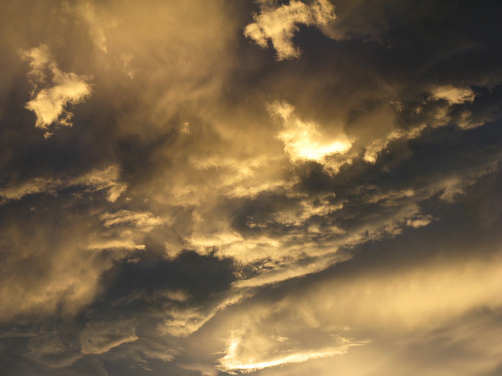
This would prove to be my last night in New Mexico. I missed a lot, particularly the Rio Grande gorge. Ah well. At any rate, let me give it up for their skies.
.jpg)

.jpg)


No comments:
Post a Comment