June 5-6, 2009
Navajo National Monument is comprised of three small parcels within Navajo Nation that protect three renowned Ancestral Puebloan ruins: Keet Seel, Betatakin, and Inscription House. Keet Seel is the largest cliff dwelling in Arizona and second in size only to Mesa Verde’s Cliff Palace. It can only be reached by a 17.5 mile roundtrip hike, with only one backcountry overnight stay allowed. A ranger on site escorts you to the ruin. Betatakin is more user friendly; a park ranger leads a five-mile round trip hike to that ruin; unaccompanied hiking is not allowed. The third site, Inscription House, is more isolated and closed to the public.
I was not there for the ruins. I was there because the campground is halfway between Page and Mesa Verde. But the campground was excellent and also free so I decided I could stay an extra day. A hike sounded nice and Keet Seel sounded too ambitious so I signed up for the 10:00 hike to Betatakin for 10:00 the following morning.
The campground was a lush sea of sage, pinon, and juniper on a base of thick orange sand. It was also very windy. I was sitting and reading about Navajo Sandstone as it blew in my face. I huddled for protection behind my car. The sky was overcast and it seemed dark even though the sun had not yet set.
Early Friday evening and campers were pouring in. The sun did its pre-sunset drop from behind the clouds and suddenly the junipers were aglow. The wind began to taper. Navajo Nation adheres to Daylight Savings Time so there was plenty of daylight left at 8:20. I prefer this to the Arizona strategy of squandering daylight at 5:00 AM. The sunset through a strange cloud cover proved spectacular. Practically the entire campground population assembled to watch it.


Two rather loud guys were sending pictures of the sunset to a friend back at work. “We’re at Keet Seel” they said. “It’s fuckin’ amazing.” Well, they were an 8-mile hike from Keet Seel. They also claimed to be “a million miles from work” and they were exaggerating there as well. Maybe they would eventually attain both.
Saturday morning was overcast but pleasant enough until the wind started in again. I joined a group of eight or so on the ranger-led tour to Betatakin. The national monument is just a sliver cut out in Navajo land. We drive our cars in a little caravan to a dirt parking lot and a locked gate and walked along an old dirt road for a mile and a half before reaching Tsigi Point and a great overview of Tsegi Canyon, the main drainage for Shonto Plateau. The canyon is enormous, while the Laguna Creek appeared tiny. It was running, though I was not sure if flowed year round. A decent amount of greenery grew between the enormous canyon walls. It is certainly better watered than Chaco Canyon.
 |
| Tsigi Canyon |

The guide was quiet but knowledgeable, particularly about plants. Her great grandmother was a herbalist and she has learned from her mother and grandmother. She was sensitive to the Navajo/Pueblo dilemma, disputing the “enemy” translation of Anasazi, attributing it to mispronunciation. To her Anasazi simply means “previous inhabitant who was not us“, and since the Anasazi and the Navajo did not coexist in place, the distinction seemed a plausible one. The contemporary relationship between Navajo and Pueblo peoples is reportedly tense.
The trail dropped 700 feet to the canyon floor before headingup into Fir Canyon, a tributary of Tsegi. Fir Canyon grows increasingly lush the higher up you go, with thick clusters of gambel oak and relic stands of conifers, a rare occurrence at 7000‘ on the Colorado Plateau. Navajo Sandstone is a famously porous rock. Rainwater and snowmelt permeate the sandstone until the water hits the underlying Kayenta Formation, a far less porous mudstone. Where the two formations meet, the water tends to move laterally, and where this transition occurs above ground level as it does here in Fir Canyon, the water emerges as springs along the canyon walls, eventually creating the Betatakin alcove as well as watering its canyon.

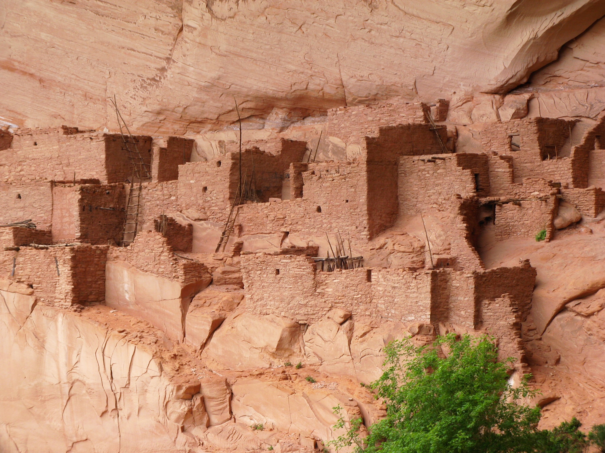
Betatakin sits almost demurely in one of the largest alcoves in the Colorado Plateau, and that takes in a lot of enormous alcoves. According to Roberts it is 425’ high, 370’ broad, and 135’ deep. The ruins themselves are superb. Betatakin looks in many ways to be the perfect cliff-house community. The term “house” suggests single-unit residence, so apartment building is more accurate. Except these people did not live in isolation like most contemporary apartment dwellers. Hence, “community“. The ruins appear to be very well preserved under the protective sandstone arch, and overlooking this small lush canyon, tributary to a larger canyon system, they were the most attractive ruins-setting ruins I saw my entire trip. If I were to choose a canyon alcove to live in of those I’ve seen, this would be the one.
 |
| Betatakin |
 |
| Betatakin |
 |
| Betatakin |
 |
| Betatakin |
 |
| Betatakin |
Ironically, this picturesque ruin that looks so attractive 700 years on was one of the most briefly inhabited of all identified Ancestral Pueblo communities. Archaeologists date the first permanent residents at around 1268, a growth of population between 1275-1280 peaking at about 125 people, the last wood beam cut in 1286, and complete abandonment of the canyon by 1300. The whole thing took place in less than two generations. Call it abandonment or migration, it’s abruptness is puzzling. “There is no evidence of violence or hasty departure.”
Cliff dwellings were quite uncommon for the Ancestral Puebloans, but they are far better preserved than the more ubiquitous ground dwellings and have received far more attention. Protected in parks and monuments, it is easy for us to think of them as representing the pinnacle of the culture. In fact the cliff houses of Navajo NM appear to be a cultural phase in its last gasps. This is not something the park service really brings home. You pretty much have to learn this on your own.
No comments:
Post a Comment