I drove north through Augusta and Choteau, a Rocky Mountain Front worthy of the name running parallel to the west, ranches and wheat fields in between. I stopped at the ranger station in Choteau - the Rocky Mountain Ranger District of Lewis and Clark National Forest - to gather info on a side-trip I would not be making into the Bob Marshall Wilderness Area. Not this time anyway. I Crossed the Blackfeet Indian Reservation into Browning and then entered the Two Medicine Area of Glacier National Park. Another exclamation point for me!
Like Rocky Mountain and Yellowstone National Parks, Glacier National Park straddles the continental divide. Two Medicine River, draining the southeast corner of the park, is about as far northwest as one can go in the Missouri River watershed, and Two Medicine Campground had a decidedly northwest feel to it. Mostly it was the weather. A thunderstorm circled overhead for an hour before producing a hard rain, but once the storm passed a light, pleasant northwest rain persisted for much of the evening. When it finally stopped I puttered around the lake taking a few pictures. The landscape had a moosey look about it, though I saw no moose. The next morning the sun was out and I took a couple of the same pictures in the dramatically different light.


The Two Medicine area had some tempting short hikes but I needed to set out early to get a campsite at the popular Many Glacier Campground in the northern section of the park. I crossed Cut Bank Creek which is absolutely as far northwest as you can go in the Missouri watershed, draining a corner of Triple Divide Peak, whose meltwaters flow to three distant seas. Cut Bank Creek merges with Two Medicine River to form the Marias River, which flows into the Missouri River on its way to the Gulf of Mexico. To the west, the peak’s high headwaters drain to the Flathead River, a tributary of the Columbia River and thus the Pacific Ocean. Finally, Saint Mary River flows northeast from Triple Divide Peak, out of the park into Canada, on to the Saskatchewan River and eventually into Hudson Bay. I was about to enter the Hudson Bay Watershed!
I had one last Missouri high tributary to cross, the Milk River. It rises in the foothills east of Glacier National Park, flows parallel to Saint Mary River northeast into Canada but veers due east and reenters the United States to eventually hit the Missouri River east of Fort Peck Reservoir. I, however, drove north along Saint Mary Lake to the town of Babb, then west along Swiftcurrent Creek to reenter the national park at Lake Sherburne, entrance into the Many Glacier area, which includes a lodge, a motel, cabins, a campground, and a small marina.
The first thing I saw in the motel parking lot was a small crowd gathered around a ranger who had two scopes focused on the high slopes above. I grabbed a campsite but before I even pitched my tent went straight to the business at hand: charismatic megafauna. Through one scope I saw a silverback grizzly foraging high on the slopes above the motel. My first grizzly bear. Up the slopes on the other side of the parking lot the scope was focused on seven bighorn sheep.
In the afternoon I set off on a short hike to Apikuni Falls (2RT/700'), my first real foray into grizzly country. I tried a little self-conscious singing and clapping, but mostly hoped that the young couple out ahead of me would either scare away or fall victim to any hovering grizzly. I later learned that grizzly confrontations often occur when a bear flees to avoid one party only to come upon another party in its flight. We all survived that afternoon.


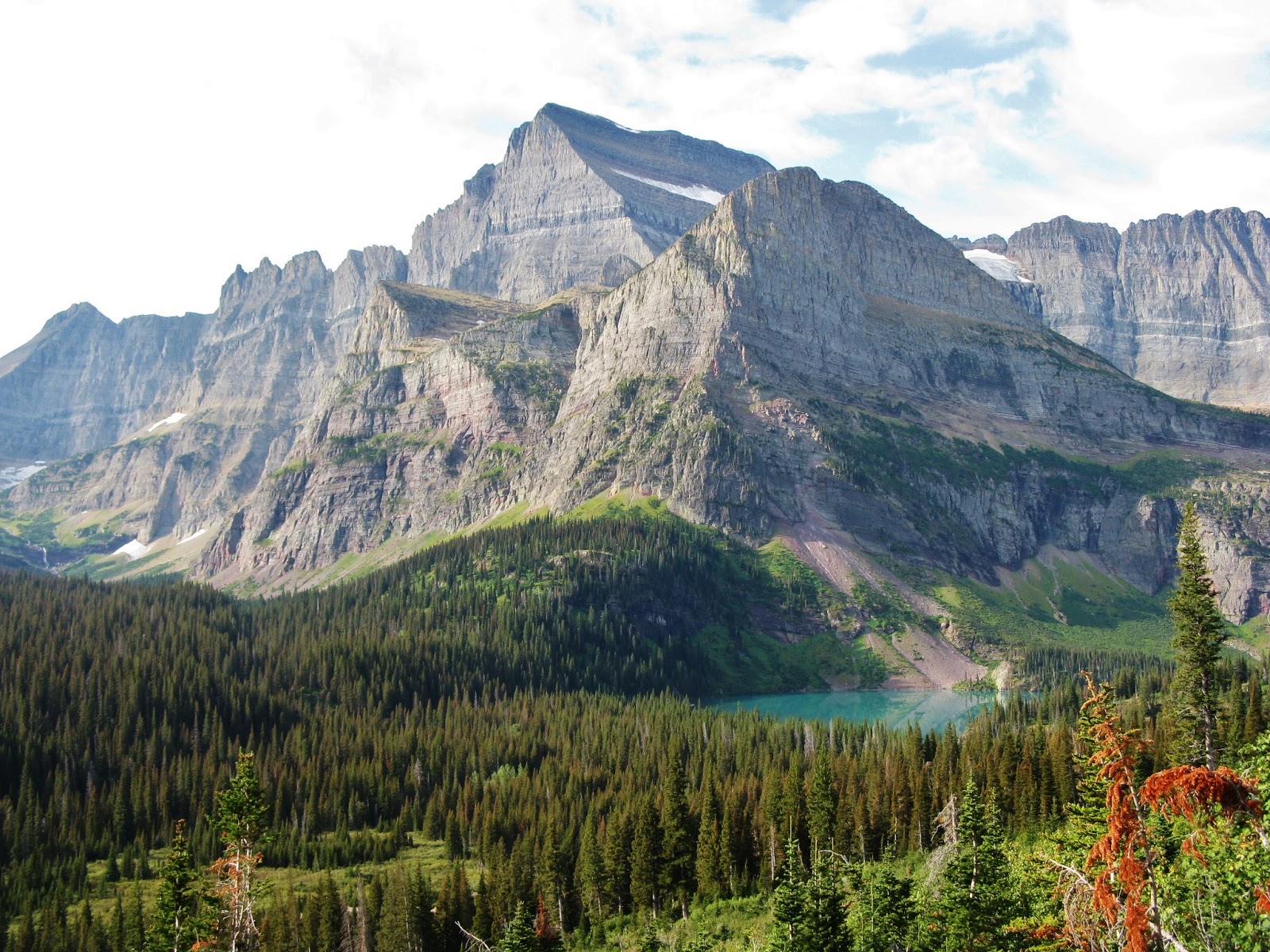
After dinner I took the short stroll to Fishercap Lake, reputed to be a good place to see moose. I saw some deer and a beaver den, plus some classic mountain landscapes.
.jpg)


Figuring a large group would be the safest introduction to hiking in grizzly country, I joined a ranger-led hike to Iceberg Lake. Though nearly five miles one way, the slope was so gentle the hike has only a 1200’ elevation gain. Still, I lagged behind the group with my labored breathing. The ranger stopped often to provide info and I would catch up in time to hear part of his talks. "Ranger John" knew a lot about berries. He stated that the entire national park was comprised of sedimentary rocks. I pointed out rocks that looked volcanic to me, and he said a closer look would prove otherwise. Of course he was right. He also mentioned that park personnel scoop up and freeze park road kill, then lay it out in the spring in an effort to keep emerging grizzlies out of the neighborhood sheep.
 |
| Bringing up the Rear |


I was struck by the sharp relief of the landscape. Compared to many places in the Rockies, Glacier National Park has a low baseline elevation. Many Glacier Campground sits at 4900’, and Iceberg Lake, our destination, barely above 6000’. At 9553', Mount Gould was lower than some Colorado campgrounds, yet it soared above its surroundings more dramatically than nearly anything I’d seen in the southern Rockies. The effect is intensified by the intense sculpting Pleistocene glaciers carved into the the peaks, creating a refined ensemble of horns, arêtes, etc. In addition, the mountains of Glacier rise well above treeline, allowing the hiker to view their entirety from the trail.

The next morning I drove up the Going to the Sun Road to Logan Pass. Logan Pass is only 6640', yet is very alpine. It looked spectacular but was too cold and windy for me.


I retreated down the road to Virginia Creek, which flows into St Mary River right above St Mary Lake, and hiked a three mile trail of waterfalls. St Mary and Virginia were the featured falls, but the whole trail runs along the tumbling creek and past any number of smaller falls, a couple as nice as either of the stars. The creek cuts through colorful sedimentary layers so that the creek bed and bank lend mightily to the aesthetics. Not very many people were out.
 |
| St Mary Falls |


.jpg)
 |
| Virginia Falls |
I found some sun on a rocky beach along Saint Mary Lake. It was one desolate beach, a long way from Tenaya Lake. The sky was bizarrely bifurcated. The entire east side of the pass was cloudy while the west side was blue. The sun was at the cusp. Most of the trees on the east side of the lake were dead or dying, and a bald mountain rose between them and the thick clouds. While further west under the blue sky the trees lived on greenly, a haunting juxtaposition.


I went into Browning and shopped with the Blackfeet at a very expensive IGA. I had not been feeling noticeably better from day to day, but of course I hadn’t exactly been resting either. Still, I woke up early Saturday feeling surprisingly good. I went down to the bridge crossing Swiftcurrent Lake and witnessed spectacular sunrise lighting over the lake and the wondrous mountainscape beyond. A professional photographer could have filled half a book.


.jpg)
I decided to invest this good feeling on a hike to Grinnell Glacier and it too was spectacular. A little tougher than the trail to Iceberg Lake, a little further, a little steeper,but I was not with a group so I could go at my own pace. The trail began with increasingly phenomenal views of the monumental Mount Gould, an architectural masterpiece. More distant views of the fragmented Grinnell Glacier offered promise for what lay ahead. In the meantime I simply glided along open landscape and pondered the sedimentary exposures, mind-boggling in their own way.
 |
| Mt Gould |
 |
| Mt Gould |


Finally the rain and clouds passed, but it was time for me to go. The weather was beautiful on the way back and I felt a bit envious of the people who were just then hiking up. Of course I had a great return hike, checking out with different light the many things I missed on the way up.
.jpg) |
| Lower Grinnell Lake |

.jpg)
I felt pretty good afterward, though the next day is always the test. Had I finally broken out of this illness? Well no it would turn out, but I was glad I went because the weather immediately deteriorated. Rain resumed at bedtime and while sunrise the next morning was magical - lighting up the thick low clouds, glowing peaks highlighted against a black sky backdrop - once the sun crossed the narrow strip between horizon and cloudbank the day was dark, drizzly and windy. The forecast called for a week of rain, so I would have never gotten another chance.

I chatted briefly that morning with a couple of women in the campground. They had Washington plates and were urban looking so I figured Seattle, but they told me they had flown in from New York City and rented a car in Helena. Go figure. Another couple was packing their tent and shedding their stove fuel for the plane home. I feel a bit envious of them too. I pondered whether to stay put, saving the pain of packing up and resettling, and at least taking advantage of the windbreak of the lodgepoles. I would have preferred a new view, but where, and to do what?
I packed up and headed out, stopping in Saint Mary only for gas, and briefly at the surprisingly barren Visitors Center. The Going to the Sun Road was cold. I took the short walk to Brainard Falls, and a shorter walk to Sunrift Gorge.
 |
| Brainard Falls |
.jpg) |
| Sunrift Gorge |
Logan Pass was once again freezing and now also hailing. People were out there hiking but alas not me. I drove on along the Going to the Sun Road and came upon - guess what? - road construction. I had to follow a pilot car and couldn't stop to look at the wondrous views, and the immediate surroundings were a construction mess. This made five straight world-class scenic roads that were under construction when I drove them.
Down on the west side, Avalanche Campground looked fine but was closing for the season at noon on Labor Day, fifteen minutes away. Sprague Creek had a few good sites, all taken, while the rest were rather sad. So I drove down to Azgar Campground and grabbed site #198 - I kid you not - but it was leafy, spacious, and warm enough for the time being. I ate lunch and passed out, obviously not well. Upon waking I felt distinctly autumnal.
The sun went back in leaving dark dank and dismal to reign. I was back in the tent from the northwest rain, rain you can hear but not feel. Even if I were well the weather would remain an impediment, though I would probably hike anyway. I wanted to be out hiking on high mountain ridges in the late summer sun. Instead Labor Day echoed Fourth of July, in my tent in a wet green forest, this one punier than Arizona’s White Mountains.
For some reason I felt like I was in Canada. Only by coincidence was I reading an excellent novella called The Man Who Finished Edwin Drood by a Canadian named David Helving. It featured Uncle Wicked, Jane the Carpenter, and the Duchess, who taught a class called Life Skills, a subject regrettably not offered when I was in school. Helvig, read the cover blurb, is right up there with Alice Munro, Margaret Atwood, and Michael Ondaatje among Canadian readers, but is unknown in America. This book, according to the publisher (Bunin and Bannigan) was "sure to delight American readers". It was published in 2007 and sank like a stone, no thanks to me.
Since the forecast was so grim I decided I was done with Glacier for this trip. I would head back south, to Yellowstone and Grand Teton. Before leaving I stopped at the West Glacier Visitors Center, and while this one was better than St Mary, it was still disappointing. Compared to other major national parks, Glacier National Park has a surprising paucity of published information dedicated to it. No official guide. Few information handouts. The rangers seemed to have a lot of information; clearly research is being done. I wondered what was with the outreach? The park would be celebrating its centennial as a national park in 2010, and I hoped maybe they’d be publishing something significant for that.
George Bird Grinnell's name is all over the park. He is practically its John Muir. Yet the bookstore had nothing by or on him. When I got home I investigated and learned it wasn't the bookstore’s fault. The publishing industry doesn't have much on him either. Shouldn't someone anthologize his articles for Field and Stream?
No comments:
Post a Comment